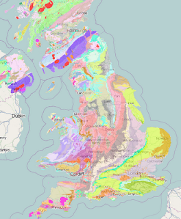
This evening I've discovered from Mapperz that the British Geological survey publishes KML files of UK geology.
I thought it would be interesting to see if these could be overlaid onto an OSM base map. If you are patient enough, they can.
The file is in KMZ format, which I couldn't get to work, so I've de-compressed it to extract the KML content. But be warned, there is more than 17mb of data being shunted around here, so everything moves very, very, very slowly.
Even in this condition, I think it is worth the effort. It's beautiful and fascinating, as I hope the image shows. At least for now, you can view the whole shebang here (eventually). I hope you find that it is worth the wait, and maybe somebody more skilled than I am can figure out how to make it all happen a bit faster. Meanwhile, start it up, then go and put the kettle on.
2 comments:
Looks good, glad to see it being using in other mapping api's.
Nice to see UK Government Organizations making datasets available.
A recent visit to the Met Office is also encouraging, they want to open the access. Just they have to protect there commercial interests/areas too.
Will be nice to see Ordnance Survey open many mid-scale datasets up soon April 2010..
@mapperz
Thanks Mapperz. This is an enormous amount of data for the browser to handle, and FWIW it seems to work faster on Chrome than IE or Firefox (at least on my system).
Post a Comment