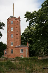
The weather forecast for this weekend suggested that Saturday would be a better day for a ride than Sunday, but I've had the semaphore tower at Chatley Heath on my list of places to visit for a while, and it only opens one day a month, so I decided to face hotter and windier weather for the sake of the destination.
Chatley Heath Semaphore Tower is one of a line of semaphore towers that were used to send messages from the Admiralty in London to the navy in Portsmouth (a distance of about 70 miles). It was used from 1822-1848, and restored by Surrey County Council in 1989. They have displays and models to show how it all worked. As you would expect there are good views from the top of the tower.
I rode out through Datchett, Staines, Shepperton and Weybridge, taking the passenger ferry from Shepperton to Weybridge. I came back through Ripley, Woking and Ascot, with a bit of a diversion in Woking on a whim to follow the Basingstoke Canal for a few miles.
The whole area around Chatley Heath is very thoroughly mapped on OSM, and there is nothing I can add from today's outing. Indeed without thorough coverage on OSM and the Cycle Map I wouldn't have discovered that the best way to approach the tower on a bike is from Pointers Road on the other side of the M25. The map showed me a local cycle route (E2) which runs from Weybridge, and makes a very neat negotiation around the junction between the A3 and M25. I could never have worked that out for myself, and would otherwise have avoided that route.
As predicted the day was quite hot, and the wind was a bit blustery. Apart from a few minor glitches, all went according to plan for total of 64 miles, and an unusual, but worthwhile destination.
Showing posts with label jaunts. Show all posts
Sunday, 4 July 2010
Sunday, 23 May 2010
An early trip to Dibley
Turville (a.k.a. Dibley) was the destination for a rather short ride early today, that I completed before the heat of the day really kicked in.
Somebody once told me that one of the milestones as a "silver" cyclist raises their game is when they realise that they have stopped avoiding hilly routes, and started to seek them out. I'm not sure that I've passed that point yet. But I don't avoid hills to the extent that I used to. I can handle most that I come across around here, though I sometimes route around them on longer rides and I'm certainly not ready to climb the escarpment between Watlington and Christmas Common. On the whole, though, I now tend to chose routes on the basis of interest and novelty rather than gradient.
In Scotland, however, I came to realise that there are hills and there are HILLS. If I'm going to attempt some more adventurous routes in more rugged landscape I really need to get some practice in. Seen in that light my short rides since I got back home have been embarrassingly flat and easy.
It's a hot weekend, and I'm falling behind on a few other tasks, so I wasn't up for a full day of riding today. I wanted to pick a fairly short ride that wasn't too wimpy, so I returned to an old favourite that loops through Marlow, Fingest, Turville and Hambledon.
From home this involves a short climb over Winter Hill to Marlow, then a longer climb north of Marlow. For once nobody passed me on the climb out of Marlow. Admittedly that owed most to the fact that I'd made an early start and there weren't many people around at 8 am on a Sunday morning. Nevertheless I was noticeably faster up the hill, and not puffing and panting to the usual extent. Once that climb is over it's an easy ride over to Turville, then down to Hambledon, where I stopped for a coffee at the village shop.
The route back into Marlow is more spiky, with a couple of quite steep sections. I've promised myself that one day I'll manage to climb those without getting off and pushing, but unfortunately that day is still in the future. I did a little bit better than usual though. By the time I was free-wheeling back down the long hill into Marlow there were dozens of perspiring cyclists puffing and panting in the other direction. If I'd had a couple more hours in bed, or if they had started a couple of hours earlier I'm sure some would have been passing me. But perhaps not all of them.
I'm wiling to make a bit of effort to tackle more demanding hills, but I'm not all that energetic. So from Marlow I chose the longer flatter route home through Bourne End and Cookham rather than climbing back over Winter Hill. After stopping for an ice cream and boat watch at Boulter's lock I arrived home just after 11 am.
When I first discovered this route I used to view it as a full day's outing. Today it took just under four hours for thirty-odd miles (including a couple of decent breaks). Not all that impressive, but an improvement which shows that even silver cyclists make some progress.
Somebody once told me that one of the milestones as a "silver" cyclist raises their game is when they realise that they have stopped avoiding hilly routes, and started to seek them out. I'm not sure that I've passed that point yet. But I don't avoid hills to the extent that I used to. I can handle most that I come across around here, though I sometimes route around them on longer rides and I'm certainly not ready to climb the escarpment between Watlington and Christmas Common. On the whole, though, I now tend to chose routes on the basis of interest and novelty rather than gradient.
In Scotland, however, I came to realise that there are hills and there are HILLS. If I'm going to attempt some more adventurous routes in more rugged landscape I really need to get some practice in. Seen in that light my short rides since I got back home have been embarrassingly flat and easy.
It's a hot weekend, and I'm falling behind on a few other tasks, so I wasn't up for a full day of riding today. I wanted to pick a fairly short ride that wasn't too wimpy, so I returned to an old favourite that loops through Marlow, Fingest, Turville and Hambledon.
From home this involves a short climb over Winter Hill to Marlow, then a longer climb north of Marlow. For once nobody passed me on the climb out of Marlow. Admittedly that owed most to the fact that I'd made an early start and there weren't many people around at 8 am on a Sunday morning. Nevertheless I was noticeably faster up the hill, and not puffing and panting to the usual extent. Once that climb is over it's an easy ride over to Turville, then down to Hambledon, where I stopped for a coffee at the village shop.
The route back into Marlow is more spiky, with a couple of quite steep sections. I've promised myself that one day I'll manage to climb those without getting off and pushing, but unfortunately that day is still in the future. I did a little bit better than usual though. By the time I was free-wheeling back down the long hill into Marlow there were dozens of perspiring cyclists puffing and panting in the other direction. If I'd had a couple more hours in bed, or if they had started a couple of hours earlier I'm sure some would have been passing me. But perhaps not all of them.
I'm wiling to make a bit of effort to tackle more demanding hills, but I'm not all that energetic. So from Marlow I chose the longer flatter route home through Bourne End and Cookham rather than climbing back over Winter Hill. After stopping for an ice cream and boat watch at Boulter's lock I arrived home just after 11 am.
When I first discovered this route I used to view it as a full day's outing. Today it took just under four hours for thirty-odd miles (including a couple of decent breaks). Not all that impressive, but an improvement which shows that even silver cyclists make some progress.
Sunday, 17 January 2010
Ordnance at Heathrow
William Roy (1726-1790) spent 1747-1755 mapping Scotland as a civilian working for the army, then joined the army, rising to major-general. In 1763 and 1766, he proposed a 'general Survey of the whole Island at the public cost'. This was seriously considered by the government, but dropped due to the expense. In 1783, he made a small triangulation around Greenwich. In the same year, Cassini de Thury, then Director of the Paris Observatory, suggested the triangulation of southeast England which could be connected to the completed triangulation of northeast France to determine the disputed relative positions of the Paris and Greenwich Observatories. Sir Joseph Banks, proposed that Roy carry out the project and Roy accepted.
The first operation was the laying out of a base line and Roy selected Hounslow Heath as a suitable location, not only for the southeast of England but also with an eye to extending the survey to the rest of the country. Starting on 16 Apr 1784 and continuing through the summer, a length of 27,404.72 feet (about 5 miles) was set out and measured three times - using cased glass tubing made by Ramsden, seasoned deal rods and a coffered steel chain made by Ramsden. The glass tubing was considered to be the most accurate, but the three measurements agreed to within three inches and the steel rods were later adopted as standard.
Sightings from the ends of the baseline to St Ann’s Hill (Chertsey) and Hanger Hill Tower gave another calculated baseline for the triangulations to Severndroog Castle (near Greenwich) and Hundred Acre (Banstead), then quadrilaterals through Frant to Hastings (Fairlight Down), and Hollingbourne Hill (Maidstone) to Allington Knoll and Dover Castle.
The triangulation was completed in 1789. In 1787, the survey had reached the coast and a line was measured on Romney Marsh using Ramsden's steel chain and the measured length agreed with the calculated length to within a foot. Roy had estimated the cost of the triangulation as £1,000, but over £2,000 was spent.
The Hounslow Heath base line was resurveyed in 1791 by Captain Williams, Mudge and Dalby, obtaining a value only 2 inches different and the average was accepted as the basic measurement.
Roy's work led to the foundation of the Ordnance Survey in 1791
In 1791, the original wooden pipes marking the ends of the base line were found to already be decayed and they were replaced by guns buried vertically. Bronze plates were attached to the guns in 1926 to commemorate the bicentenary of Roy's birth. The northwest gun was removed in 1944 due to expansion of Heathrow Airport. It was returned to its original position in 1972. The southeast gun has never been moved and is in Roy Grove, Hampton - grid reference TQ 137709.
The "Principal Triangulation" begun by Roy continued until 1835, but was eventually superseded by a re-triangulation begun in 1935, and completed in 1962. This involved erecting concrete pillars (trig points) on hilltops throughout Great Britain. The re-triangulation was the basis of the British national grid reference system, and new Ordnance Survey maps.
Edited from http://www.dcs.warwick.ac.uk/bshm/zingaz/LondonPeopleN.html#roy, http://www.brlsi.org/proceedvol7/Astronomy200301.htm, and http://en.wikipedia.org/wiki/Retriangulation_of_Great_Britain
The first operation was the laying out of a base line and Roy selected Hounslow Heath as a suitable location, not only for the southeast of England but also with an eye to extending the survey to the rest of the country. Starting on 16 Apr 1784 and continuing through the summer, a length of 27,404.72 feet (about 5 miles) was set out and measured three times - using cased glass tubing made by Ramsden, seasoned deal rods and a coffered steel chain made by Ramsden. The glass tubing was considered to be the most accurate, but the three measurements agreed to within three inches and the steel rods were later adopted as standard.
Sightings from the ends of the baseline to St Ann’s Hill (Chertsey) and Hanger Hill Tower gave another calculated baseline for the triangulations to Severndroog Castle (near Greenwich) and Hundred Acre (Banstead), then quadrilaterals through Frant to Hastings (Fairlight Down), and Hollingbourne Hill (Maidstone) to Allington Knoll and Dover Castle.
The triangulation was completed in 1789. In 1787, the survey had reached the coast and a line was measured on Romney Marsh using Ramsden's steel chain and the measured length agreed with the calculated length to within a foot. Roy had estimated the cost of the triangulation as £1,000, but over £2,000 was spent.
The Hounslow Heath base line was resurveyed in 1791 by Captain Williams, Mudge and Dalby, obtaining a value only 2 inches different and the average was accepted as the basic measurement.
Roy's work led to the foundation of the Ordnance Survey in 1791
In 1791, the original wooden pipes marking the ends of the base line were found to already be decayed and they were replaced by guns buried vertically. Bronze plates were attached to the guns in 1926 to commemorate the bicentenary of Roy's birth. The northwest gun was removed in 1944 due to expansion of Heathrow Airport. It was returned to its original position in 1972. The southeast gun has never been moved and is in Roy Grove, Hampton - grid reference TQ 137709.
The "Principal Triangulation" begun by Roy continued until 1835, but was eventually superseded by a re-triangulation begun in 1935, and completed in 1962. This involved erecting concrete pillars (trig points) on hilltops throughout Great Britain. The re-triangulation was the basis of the British national grid reference system, and new Ordnance Survey maps.
Edited from http://www.dcs.warwick.ac.uk/bshm/zingaz/LondonPeopleN.html#roy, http://www.brlsi.org/proceedvol7/Astronomy200301.htm, and http://en.wikipedia.org/wiki/Retriangulation_of_Great_Britain
See also http://www.twickenham-museum.org.uk/detail.asp?ContentID=276 and a biograhpy of Roy, at http://www.remuseum.org.uk/biography/rem_bio_roy.htm
Sunday, 2 August 2009
Bicycle window
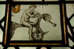
After several attempts I finally got to see the famous bicycle window in St Giles church, Stoke Poges this afternoon.
The stained glass dates from 1643, and the image appears to show a naked cyclist on a "hobby horse" blowing a trumpet.
As....
a) the "hobby horse" was not invented until the nineteenth century
b) The Naked Bike Ride idea didn't emerge until 2004
...there is presumably some other explanation for what is going on here.
The stained glass dates from 1643, and the image appears to show a naked cyclist on a "hobby horse" blowing a trumpet.
As....
a) the "hobby horse" was not invented until the nineteenth century
b) The Naked Bike Ride idea didn't emerge until 2004
...there is presumably some other explanation for what is going on here.
Sunday, 7 June 2009
Mad King George
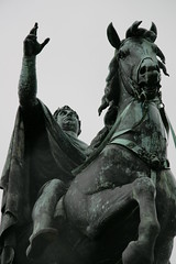
In Windsor Great Park there is a huge statue of George III on the top of a hill, at the end of the Long Walk, in direct line of sight from the castle.
You would think it would be easy to find.
It's probably worth pointing out that you are not allowed to ride a bike on the obvious route, along the Long Walk. But it still doesn't say a lot for my navigation skills that it's taken me four or five attempts to find another route to the statue, which is known as the "copper horse".
However, this afternoon I finally made it, in fairly grim weather, with light drizzle on the way out, a heavy shower when I got there (I sheltered under a tree for a while), then more drizzle for half the journey back.
It's a horrible statue, but I'm glad I've finally crossed this off my list of things to visit on the bike.
Even better, on the way down the hill I rode past a herd of deer that were making their way across the road.
It's a horrible statue, but I'm glad I've finally crossed this off my list of things to visit on the bike.
Even better, on the way down the hill I rode past a herd of deer that were making their way across the road.
Even if it was possible, it's not a good idea to get too close, so the picture seems a bit unimpressive. In the real world, seeing so many deer at (fairly) close quarters was something memorable.
Saturday, 30 May 2009
An epic day
Today I've ticked off two more Jenkins churches (Saint George, Esher & Saint Mary, Stoke D'Abernon). I've covered another chunk of one of the cycle rides that Charles G. Harper described in 1902. And I've fitted in a few more highlights between, including taking the bike onto the water, across the river between Weybridge and Shepperton (on the ferry). All in less than 70 miles.
My route was down the Jubilee river to Datchett, then the Thames path to Hampton Court. From there, south to Sandown Park, and Esher. Then Portsmouth Road and minor roads across country to Stoke D'Abernon. I made my way back through Cobham and Weybridge to the Thames, then Shepperton, Staines and Windsor to home. All went to plan, apart from getting a bit muddled between Staines and Egham.
Too much to fit into one post, so there is more to follow.
Sunday, 19 April 2009
St Mary, Thame
Today was a good example of my self-imposed Jenkins quest at its best. The basic idea is that I use the bike to visit the best of England's churches (as chosen by Simon Jenkins). Each time I visit one, the next is a bit further away. So it forces me to discover new routes, and gradually increase my mileage.
I like old churches. They have been the heart of their communities for generations, and at their best they capture a unique atmosphere. Sometimes exploring my destination is an additional bonus. But when it comes to the crunch the main point of the quest is not the destination, it is the ride.
When I reached Thame, the church was locked. It looks impressive, and it sounds as though the interior would be interesting, but all I could see was the outside and the churchyard. I suppose I could have gone to find a key, but time was short, so I moved on.
I like old churches. They have been the heart of their communities for generations, and at their best they capture a unique atmosphere. Sometimes exploring my destination is an additional bonus. But when it comes to the crunch the main point of the quest is not the destination, it is the ride.
When I reached Thame, the church was locked. It looks impressive, and it sounds as though the interior would be interesting, but all I could see was the outside and the churchyard. I suppose I could have gone to find a key, but time was short, so I moved on.
Thame isn't very well covered on Open Street Map, and I think I will be able to add a few more streets. But my journey out to Thame, via Marlow and Stokenchurch, then back via Princes Risborough and High Wycombe is already well covered.
It's now a common experience, on the long climb out of Marlow to be overtaken by someone older but fitter, who passes with a cheery "hello", at a much faster speed. Infuriating. Today was no exception.
On the return journey, along the Phoenix trail from Thame to Princes Risborough, other cyclists were mostly families. It was nice to see a wide age range, including little girls on pink bikes, little boys on bikes with lots of gizmos, and fathers on high-tech mountain bikes. Elsewhere the people on bikes were mostly what I think of as "proper cyclists" with knobbly legs, and brightly coloured lycra.
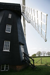
Beyond Princes Risborough I rode past the windmill at Lacey Green, then RAF headquarters at High Wycombe. It's a lovely fast ride down a long descent from Lacey Green to High Wycombe.
So a special day. Fifty-odd miles in total. And all of this because I set out to visit a church in Thame, which wasn't even open when I got there. And why not?
Subscribe to:
Posts (Atom)