Some question my theory about where the names of lanes come from.
The following instructions were issued to OS surveyors.
"For names generally the following are the best individual authorities, and should be taken in the order given. Owners of property; estate agents; clergymen, postmasters and schoolmasters, if they have been some time in the district; rate collectors; road surveyors; borough and county surveyors; gentlemen residing in the district; Local government Board Orders; local histories; good directories ... Respectable inhabitants of some position should be consulted. Small farmers or cottagers are not to be depended on, even for the names of the places they occupy, especially as to the spelling, but a well-educated and intelligent occupier is, of course, a good authority"
On the basis that the Ordnance Survey must have had good reason for issuing these guidelines, I rest my case m'lord.
I found the quote in Mike Parker's excellent book "Map Addict", but it is also quoted here with a lot more information about how it all worked,
Monday, 26 April 2010
Saturday, 24 April 2010
A brief conversation
This afternoon I was waiting at a junction for a gap in the traffic when a cyclist half my age, and fully lycra'd pulled up alongside on a very expensive looking high technology road bike .
We had a quick chat about potholes as the cars rushed by. When the first gap appeared he said "See you then".
"You don't think I'll keep up with you?"
"Perhaps"
I didn't, of course. I've got nothing to prove,
We had a quick chat about potholes as the cars rushed by. When the first gap appeared he said "See you then".
"You don't think I'll keep up with you?"
"Perhaps"
I didn't, of course. I've got nothing to prove,
Friday, 23 April 2010
Go through puddles
It's now six weeks since I picked up the new bike, so today it's been back to the shop for its free service / check-up. They needed it for a couple of hours, so after dropping it off I wandered into town, mooched around for a bit, bought a book, found a café, read the book, then mooched around a bit more before picking the bike up, and bringing it home for a trial. They've trimmed things up nicely, and it is riding beautifully.
The book I bought was the Lonely Planet "Cycling Britain". Normally I'm a bit wary of national guides to cycle routes. Some offer good ideas that provide a basis for inventing local routes, but most use 80% of the space to describe short routes that are so far way that I couldn't realistically try them out, even if I wanted to.
The Lonely Planet guide, on the other hand, concentrates on routes that last a week or so. All of them are practical options for a cycling holiday, and parts of most are reachable for a short break. Even better, one route is similar to the one I am planning to ride in a few weeks time, and there are a couple that I've been considering for future trips. I've also ridden bits of the local routes that they cover, so I am able to compare my impressions with some of theirs.
I'd be interested in other views, but my first reaction was that there are an alarming number of typos for a book that has been around for nearly ten years, and that is in its second edition. Having said that, it reads as though they have actually ridden what they are writing about. When they describe the routes that I know, their impressions aren't hugely different from mine. So I hope that they will be pretty reliable for the other routes.
The book seems to be targeted at an international audience so it also offers some basic advice about cycling in Britain. Some of the suggestions are pretty mundane, but I particularly like the recommendation to "go through puddles". Some might read that as a cheap jibe about British weather, but I'm inclined to add it to the other basic principles of my kind of cycling: "if you are not having fun, then you are not doing it right", "any activity that requires special clothing can't be good for you", and "stop faffing around on the internet and invent a reason to go for ride".
Thursday, 22 April 2010
Where do road names come from?
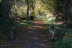
But out in the countryside, the vast majority of names seem to be functional.
My own theory is that before the gentleman from the Ordnance Survey arrived with his notebook the locals didn't really need to name the different paths through their village. Looking at the common names for a lane on OSM most are either based on an important building (Church Lane, Mill Lane, School Lane, Hall Lane, Rectory Lane,...), or they describe the lane itself (the list of examples like Green Lane, Long Lane, Sandy Lane, Marsh Lane, Water Lane, Broad Lane goes on, and on).
I imagine the surveyor turning up in the pub, putting down his top hat, and asking "what do you call that path, and what do you call that one?" and the ancestors of Eddie Grundy and his mates getting their heads together to think up some suitable names.
"Well that one's stony, and that one goes to the windmill, and the parson wouldn't be happy if we told him what we really call that one, so I suggest we tell him it's called Love Lane". "G'evening your lordship, I'm just telling old Amos here that we ought to name one of these paths after your lovely daughter Holly, who does so much for the poor folk of the parish. That would be very kind sir, I'll just have a pint please."
I've put a list here of the common names for a lane on OSM, ranked by the number of segments and total length.
Wednesday, 21 April 2010
Almost a big day today
I bunked off work early, and did a twenty-three mile loop out to Windsor and back before dinner. On the way I managed to find another blue plaque that I'd forgotten about. It commemorates Mariquita Tennant for saving fallen women.
Until just now I thought the best thing was that for the first time this year I was on track to reach my 2010 mileage goal. It turns out that the best thing must have been something else.
For complicated and unimportant reasons my goal is to cycle 3,759 miles this year. Today I passed 1,091 miles. Unfortunately I now realise that's only 29% of my target in 30% of the year. Not for the first time I'd made a mistake in a spreadsheet, and I'm still short of where I want to be.
Looking on the bright side, I'm just going to have to bunk off work early again tomorrow.
Tuesday, 20 April 2010
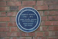
Charles Knight
According to the local authority web site there is a plaque in Alexandra Gardens, near to the river. They even provide a map that shows where it is in the gardens, but despite several detours on recent rides to Windsor I've never been able to find it. Today I discovered it hiding about quarter of a mile away, at the other end of a footpath that leads to the gardens from Thames Street. I'm going to claim that I was looking in the right place but the plaque was elsewhere. I've added it to OSM and Open Plaques.
The other plaque that I've finally been able to track down and add (pictured) is in the Old Burial Ground at the end of Madeira Walk, next to Bachelor's Acre. It's pretty much where they said it was. If I'd not been looking in the wrong place I'd have found it on my first attempt.

Charles Knight was a publisher. Among other things he published the Windsor, Slough and Eton Express, and the Local Government Chronicle, both of which are still going today. He also published the "Library of Entertaining Knowledge", and the "Penny Cyclopaedia", which are both great titles, if nothing else. There are samples from the cyclopaedia here (it's got nothing to do with bicycles).
Sunday, 18 April 2010
Dear Mr Irritated

Like most cyclists I've encountered a small number of drivers who don't think I should be on the road at all, and a few who think cyclists are supposed to use cycle paths whenever they are provided, rather than the road. You are my first experience of a pedestrian who didn't think I should be on a shared-use path. Or at least the first who has told me what they were thinking.
The Highway Code is specific about how cyclists should use most facilities. We are not supposed to cycle on a pavement unless it is marked for shared use by cyclists. When it is marked for shared use then we are not obliged to use it. If we chose to use a shared pavement then we should allow plenty of room for pedestrians. We are urged to be particularly careful around children and the elderly. Even though you and your wife don’t fall into either category, I still ought to be considerate.
In other words, I had as much right as you to use the footpath, but I was under a greater obligation to be careful and considerate.
I assume you are not a cyclist. Some cyclists who ride on pavements are clearly idiots. I know some cyclists feel safer to be riding out of the way of traffic. However, my own experience is that with sufficient confidence in dealing with traffic the road generally feels safer than the pavement.
I almost always chose the road. Progress is quicker. There are fewer obstacles to avoid and fewer junctions to negotiate. Cycling on any footpath brings a constant fear that a car will shoot out or cut across unexpectedly. Vehicles on the road are bigger, faster, and more scary than pedestrians, but they are also more predictable. By the time you have taken sufficient care riding anywhere near a loose child on a footpath you might as well get off and walk. So normally the road is faster, safer, and on top of all that it often provides a more comfortable ride.
So yesterday I was on the shared footpath for a different reason. As you will remember, the footpath was just about wide enough for cycles and pedestrians to pass each other. More to the point, the road wasn't wide enough for a car to pass a bike without crossing into the approaching lane. You and your wife were the only people on the path (apart from me), but there was a steady stream of cars passing in both directions. Any cyclist on that road was forcing traffic to chose between following at the same pace, or waiting for a gap in the opposite carriageway to shoot past. In the previous section of that road there was no shared footpath, and I’d watched several cars making a dangerous manoeuvre to overtake me. I suspect the highway engineers knew what they were doing when they designated this particular shared footpath. It was my choice entirely, but my view was that riding on the shared footpath was no skin off my nose, and less inconvenient for cars.
So thank you for your question, and please pass on my thanks to your wife for stepping aside to make room. I wish I could claim that I always ride in the way that I should, but if I’m honest with myself, I can’t. You’ve made me think again about this occasion though. I never had any doubt that I was entitled to be riding where I was. On reflection, I still reckon it was the most appropriate and considerate choice for us all.
Saint Nicholas, Compton
This is the 39th church I have cycled to from my list of notable English churches. I've ordered the list by distance from home, and Compton ranks 36th. It's just over 22 miles away as the crow flies. However, the actual distances from here to Surrey always work out further because it's difficult to find decent routes. Centres like Bracknell, Camberley, Woking and Guildford tend to get in the way, and the whole area is crossed by very busy roads. It's quite a challenge to find a route that isn't too busy or absurdly complicated.
For destinations to the east of Woking I tend to go down the Thames towards Weybridge, then head south. For destinations east of Guildford I work my way through the edges of Woking. But Compton is further to the west, and I was on unfamiliar ground.
I consulted CycleStreets for suggestions, and as usual it came up with some good ideas. But the fastest route suggested a lot of roads that I was already familiar with. The quietest route was complicated. The "balanced route" was a decent compromise, but I thought I could do better by mixing bits of each. I don't know of a way to edit routes from CycleStreets, so I turned to the Bike Route Toaster to recreate the CycleStreets suggestions that I liked. Bike Route Toaster has the added advantage that routes can easily be loaded onto my Garmin Edge.
It's the first time I've tried this, and up to a point it worked well. The glitches were down to me. In the first part of the journey I rediscovered a much quieter route to Bracknell than I've been using recently. And I managed to work my way round Bracknell mostly on cycle paths rather than on busy roads. All that went well. Unfortunately I hadn't been as smart as I thought in the route that I chose south from Bracknell, so I suffered a few miles through heavy traffic on fast roads through Camberley. From then on things went much better. The ride down through Frimley was fairly built up, but interesting. I had realised over breakfast that the final part of my plan went straight up and over the Hog's Back ridge (which didn't look like a great idea). I found a less strenuous alternative along part of the Pilgrims Way (National Cycle Route 22). So for the last few miles I deviated from the route that I'd loaded onto the GPS. It was a good call - the ride along NCR 22 was very pleasant.
Coming back I retraced my steps (steps?) as far as Frimley Green. I didn't fancy battling my way through Camberley again, so I decided to take a wider loop round Bracknell, through Deepcut, Lightwater, Windlesham and Ascot. I hadn't ridden that way before, and it looked like a much longer ride, but it was a lovely afternoon, and I had plenty of time. In the event it wasn't as far as I expected.
The total distance ended up at just over 70 miles.
Friday, 16 April 2010
Windsor and back
A quick 20 mile spin this evening out to Windsor and back. It was all very pleasant with the sun shining, a slight wind, and without too much traffic on the roads.
One strange thing, though: a complete lack of planes landing and taking off at Heathrow.
One strange thing, though: a complete lack of planes landing and taking off at Heathrow.
Thursday, 15 April 2010
More milestones

I'm not sure how complete it is, but these are the locations of milestones in England that I've extracted from the English heritage lists at Listed Building Online. The full map is here. (warning - this involves overlaying quite a large KML file, so it might take a while to load).
It's not a surprise to find that milestones link important 19th century centres like London and Bath, along the old coaching routes. But it was a bit of a surprise to find that there are enough of them left to still form little strings of pearls along major roads.
As far as I can make out the terms and conditions of the English Heritage web site allow me to use this data "for the pursuit of legitimate activities, but not in connection with any unlawful, illegal, immoral or anti-social purpose, or in a manner which, in English Heritage’s sole discretion, is or may be damaging to the name or reputation of English Heritage". I hope this post passes the necessary tests - but the conditions also seem to be saying that I can only provide a link to the English Heritage web site if I first get their written permission. Surely I must be misreading that?
Wednesday, 14 April 2010

Tuesday, 13 April 2010
Sunday, 11 April 2010
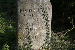
Milestone on the Bath Road
Today, for the first time, I discovered Listed Buildings Online. Again, it provides access to a wealth of information. I don't know how long this one has been around, but as far as I am aware, this kind of information was previously only available for England on individual local authority web sites, in a variety of different formats.
I suspect they rarely visit TLATET, but neverthless, I will begin by congratulating and thanking everyone involved in making this information available. Each of these sites provides a valuable resource. Unfortunately, I have to admit that each of them also demands a fair amount of determination to extract anything of interest. They duplicate each other to some extent, they are not well integrated with related information (or even with each other) and all suffer from rather clunky interfaces.
If anyone reading this is aware of alternative ways of accessing this information then I would be interested to hear about it. Meanwhile, having discovered the database of listed buildings I decided to try it out by searching for information on local milestones along the A4 (Bath Road) between Maidenhead and Twyford.
The Listed Buildings Database holds the locations of almost 3,000 milestones across England, of which 83 are in Berkshire. You don't normally see milestones from a car, and although I've spotted the odd one in passing, I never twigged that there were so many of them. I've used the grid references provided by English Heritage to plot the ones in Berkshire, here.
Once I'd extracted the data I set off on the bike to see if I could find the nearest milestones on the ground. It turns out that the grid references on the listed buildings register are remarkably precise, and I only failed to find one. Missing it is almost certainly down to me, since the others seem to be exactly where they are supposed to be.
Having returned home I discover that more sensible members of my family think that cycling fifteen miles or so to check up on a bunch of milestones is an odd thing to do. Perhaps they are right, but I reckon there are worse ways to spend a couple of hours on a Sunday afternoon. Washing the car, and sorting out the garden shed will wait another week (or two).
I discover that the above is a bit unfair on English Heritage. They also provide a gateway that aggregates the results from a variety of different databases - here .
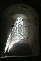
A gem of a destination

All this was brought to mind by yesterday's destination: a little gem at Rycote, just outside Thame. It used to be the chapel for a house that was grand enough in its day to be visited by Charles I, and Elizabeth I; and for Henry VIII to spend one of his honeymoons there.
The grand house is long gone, but the chapel remains. Outside it looks like a very pretty little 15th century church. Inside it is famous for the fine 17th century woodwork. There is also an ancient yew tree in the churchyard.
I was shown round by an enthusiastic and knowledgeable guide, who pointed out the highlights, and gave me enough of the history to remind me of my patchy knowledge of great historical events and characters.
Of course I already knew the memorable stuff about some of the famous people who visited Rycote. Henry VIII (wives), Elizabeth I (body of a weak and feeble woman; heart of a king). But just inside the chapel the ceiling is covered with little gold stars, that were supposedly cut out by Charles I, from a set of playing cards. So I can add to my fragmented knowledge of an unhappy man - Charles I: "wrong but wromantic"*, head chopped off, used to cut up playing cards.
It was a gorgeous day for a ride. The sun shone all day, and although there was a light breeze, it never got strong enough to be described as a wind. I rode out through Henley and up to Stokenchurch before dropping over the escarpment down to Thame. Coming back I used the Phoenix trail to get to Princes Risborough, then home through High Wycombe.
The Phoenix trail is a bit of a mixed blessing on a long ride - it follows an old railway line, so it is flat and traffic free. The result is that it is heavily used by families, and progress can be a bit slow. But it's nice to see so many families cycling together. On the way I overheard the full gamut of parental encouragement, from "do hurry up Angela" and "come along Benjamin" through "watch where you are going Oliver", "look out Penelope"; to "not so fast Veronica" "come back William" and "Zac, where have you gone?".
The tally for the log book is one more church ticked off this year's list, 56 miles added to the annual total, the new bike has covered more than 500 miles, Eddington number risen to 44, and a couple of minor details added to Open Street Map.
* according to Sellars and Yeaman in "1066 and all that"
More on the chapel and here
More on the history
More on the ancient yew
Thursday, 8 April 2010
4'11d per quart

Tuesday, 6 April 2010

Monday, 5 April 2010
Pédaler dans la choucroute
If I've got this right, to "pedal in the sauerkraut" means expending a lot of energy to very little effect. It sounds like a useful expression. It's also a pretty good description of my efforts this afternoon to beat my previous time round my regular ten mile loop.
A while back I set a reference time for this particular route of 46 minutes, and I've been using that since to measure any improvement in my speed. I've convinced myself that I ought to be able to get round the loop in 40 minutes. After all, it's only ten miles, although it is quite hilly. In practice though, I get round in about 43 minutes when I'm on good form.
This afternoon's time was 47 minutes. That's long enough to think up some good excuses, but the only plausible one today was the headwind, and I'm not entirely convinced. Goodness knows how I originally got round in 46 minutes without all this practice and new bike.
Today it was like pedalling in sauerkraut.
More OSM coverage

The release of Ordnance Survey data has triggered a mass of activity, and there is no doubt a lot more to come.
For my part I've started with another simple comparison between DfT statistics on the length of roads in Great Britain, and the length that has already been plotted on OSM - using the Ordnance Survey boundary data to break out the figures for each local authority.
For my part I've started with another simple comparison between DfT statistics on the length of roads in Great Britain, and the length that has already been plotted on OSM - using the Ordnance Survey boundary data to break out the figures for each local authority.
I've been able to identify more than three quarters of the roads measured by DfT, and the map shows how these are distributed across different local authorities. Boundaries for Northern Ireland are not included in the OS data as far as I can see, so they do not appear here.
The best coverage is in the south-east of England (with Bracknell and Luton as thin spots). There is some strong coverage in other centres of activity. The biggest shortfalls (total road length to be added) are in Aberdeenshire, Cumbria, Lincolnshire, Norfolk, N. Yorkshire and Powys. The highest proportion of missing roads is in Baenau Gwent and N. E. Lincolnshire. The figures for Lincolnshire, N. E. Lincolnsihre and Northumberland all suffer from a particularly high proportion of roads with ambiguous tagging - which I have excluded from this version.
For anyone interested in how this breaks down in more detail, the data is here -
With ward boundaries now available from OSM, I'm hoping that I can now take some of the analysis to a more detailed level, but more importantly it will be good to see some of the gaps filling over the weeks to come.
Sunday, 4 April 2010
Blue plaques

After a few demanding rides in recent weeks it was a pleasant change to just pootle about for a bit.
The great and good of Windsor had a variety of different houses, but I think I covet the one that Margaret Oliphant lived in more than most (Streetview).
She sounds like a bit of a character.
Subscribe to:
Posts (Atom)