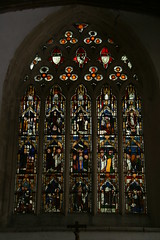
All Saints at North Moreton was one of the two churches that I visited on Saturday. Saint Andrew, at East Hagbourne was the other. Both are close to Didcot.
All Saints has been described as the most perfect medieval church in Berkshire. Which is a little odd, given that it is in Oxfordshire. It isn't the church that has moved. It's the county boundary, which was shifted in 1974 (on April 1st), when Didcot and Wallingford became part of South Oxfordshire.
All Saints is a nice enough parish church, with one outstanding feature. The stained glass in the Stapleton Chapel dates from the late thirteenth century, and even to my uninformed eye, it looks superb.For something that it is over 700 years old, the colours are stunning.
Unfortunately Saint Andrew's church at East Hagbourne was closed when I got there, so I didn't get to see the carvings, which apparently are the highlight.
My route outwards was via Henley and Wallingford. I started along the back roads to Henley, but for the sake of speed I then followed main roads. It's quite a long climb out of Henley, so at that stage I was getting quite warm, but then the temperature dropped noticeably as I descended through Nettlebed to Wallingford in a bit of light fog.
Coming back I followed National Cycle Route 5 across the hills through Stoke Row to Reading, then I crossed Reading along the towpath beside the river. The subtle colours of blue and grey along the river in the dusk were striking, but by the time I came out of Reading it was getting dark and from there I just bashed along the main road to get home.
In the past I've never managed to follow cycle route 5 coming into Reading, because I drifted off route by missing a turning. As a result I've ended up negotiating some busy roads. This time, thanks to the OSM cycle map on the GPS (and, I suspect, some better signage out on the road) I managed to follow the Sustrans route properly.
It's a fun ride, diving down little lanes, and around a park to join the river at Caversham bridge. I found it a big improvement over my previous attempts to cross Reading, and a much more interesting way to get from one side of the city to the other.
All of the roads that I followed were already on the OSM map, but neither of the churches were, so I've now added them. It's getting harder to find places locally that need mapping, but since I got home I've noticed that there are some missing minor roads quite close to the route that I followed. Next time I need to plan some short diversions to plug a few gaps.

No comments:
Post a Comment