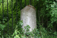
Things are fairly hectic around here at the moment so there's not a lot of time for a decent ride. However I did manage a quick spin this morning. In the process I found several more of the milestones that are still in place along the Bath road. I photographed four and added them to OSM.
I can't get over how many milestones from the 18th / early 19th century are still around. Along the old Bath Road there's a bit of a gap in Reading, but between Twyford and Slough almost all of them still seem to be in place. A lot of those across England are listed and shown here. Pictures of those on a short stretch of the Bath road are here.
The old turnpike road from London to Bath lies along what is now the A4, so in itself it's not an ideal road for cycling. But on a Sunday morning things are fairly quiet. Today I joined up part of the A4 with some nice quiet lanes and bits of the Sustrans National Route 4 to make up a pleasant circular ride of about 18 miles.
From "A booklet on the Turnpike Roads around Reading" by Alan Rosevear:
Until the late 17th century the western road out of London was referred to as the Great Road to Bristol, the nation’s most important Atlantic port. However, this emphasis changed after Queen Anne began to patronise Bath as a restorative spa. Through the genius of Beau Nash this inland town to the south east of Bristol, grew to be the premier recreational destination for the wealthy and famous during the 18th century. The only practical way to Bath from London was by road and large numbers of private vehicles and public coaches began to travel along what became known as the Bath Road.
The Bath Road through Berkshire follows essentially the same route described by Ogilby in 1675. The route west from London, through Kensington, Brentford, Hounslow and Slough was over relatively low-lying ground, underlain by London Clay. Although the route did take advantage of stretches of heathland on old river gravels, most of the ground was wet heavy clay. that was cut into deep, water filled ruts in winter and baked to a hard uneven surface in the summer. Along this northern bank of the Thames, minor tributaries such as the Brent and the Coln presented no great barrier to travel. Between Colnbrook and Maidenhead the ground was not so bad and in 1688 Pepys travelling in his private carriage was even able to comment that the way mighty good. The road was carried over the Thames at Maidenhead where a succession of bridges has stood since medieval times. From Maidenhead an exposed area of the Chiltern chalk underlies the southern bank of the Thames provides relatively firm ground for a highway. The roads to Henley and Reading branch along low chalk ridges, avoiding Ashley Hill. The Bath Road takes an easy crossing of the Loddon where it is divided into several branches at Twyford (the twin fords). It then picks a path between the river and the high ground at Woodley to reach the major crossing of the Kennet at Reading. Much of the route is over low-lying gravel terraces close to the rivers except for the section west of Maidenhead. Instead of the route taken later by Brunel’s railway, the Bath Road climbs onto the high ground to go over Knowl Hill. Whether this is a reflection of the route being pulled north along the line of the Oxford Road or was to avoid the deeper parts of the Royal Forest of Bray is not clear.

No comments:
Post a Comment