Saturday 30 January 2010

All Saints, Ockham


Today's outing was to Ockham, which is in Surrey, on the east side of the Wey Valley, 7 miles north-east of Guildford, and 20 miles from London.

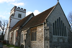
I was there to visit one of the churches in my quest to reach famous churches that are within cycling distance of home. I reckon this one is just under 20 miles away as the crow flies. Various route finders estimate more realistic journeys at about 27 miles. I actually covered a total of almost 65 miles on the way there and back. My own route planning wasn't helped by the need to cross three or four different OS maps that intersect just this side of Ockham, but I also wandered off the shortest route so that I could stick on familiar roads nearer home, and explore more interesting paths further away.

Unfortunately the church was locked, so I didn't see inside. It is famous for the seven lancet window in the east wall (seen here). But it is also associated with William of Ockham, a fourteenth century Franciscan Friar and philosopher. He worked in a number of areas but is best known for the principle of "Occam's razor", which basically says that the simplest explanation tends to be best. What we would call "Keep it simple, stupid". See Wikipedia for more on this.

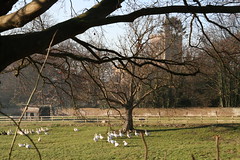
The weather today was sunny but cold, particularly in the last hour after the sun went down. But there was little ice on the roads, and it was a pleasant day for an outing (for anyone wrapped up well enough). There were quite a few cyclists out and about, and quite a lot of traffic generally on the roads.

It wasn't a particularly exceptional day, but all very pleasant, and I may have to revise my innate prejudice against Surrey (more of this anon). Highlights included a pleasant chat with an elderly gentleman in the churchyard, and I sampled my first Dragon Pasty for lunch on the way there.

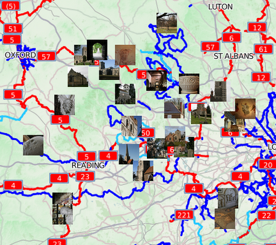
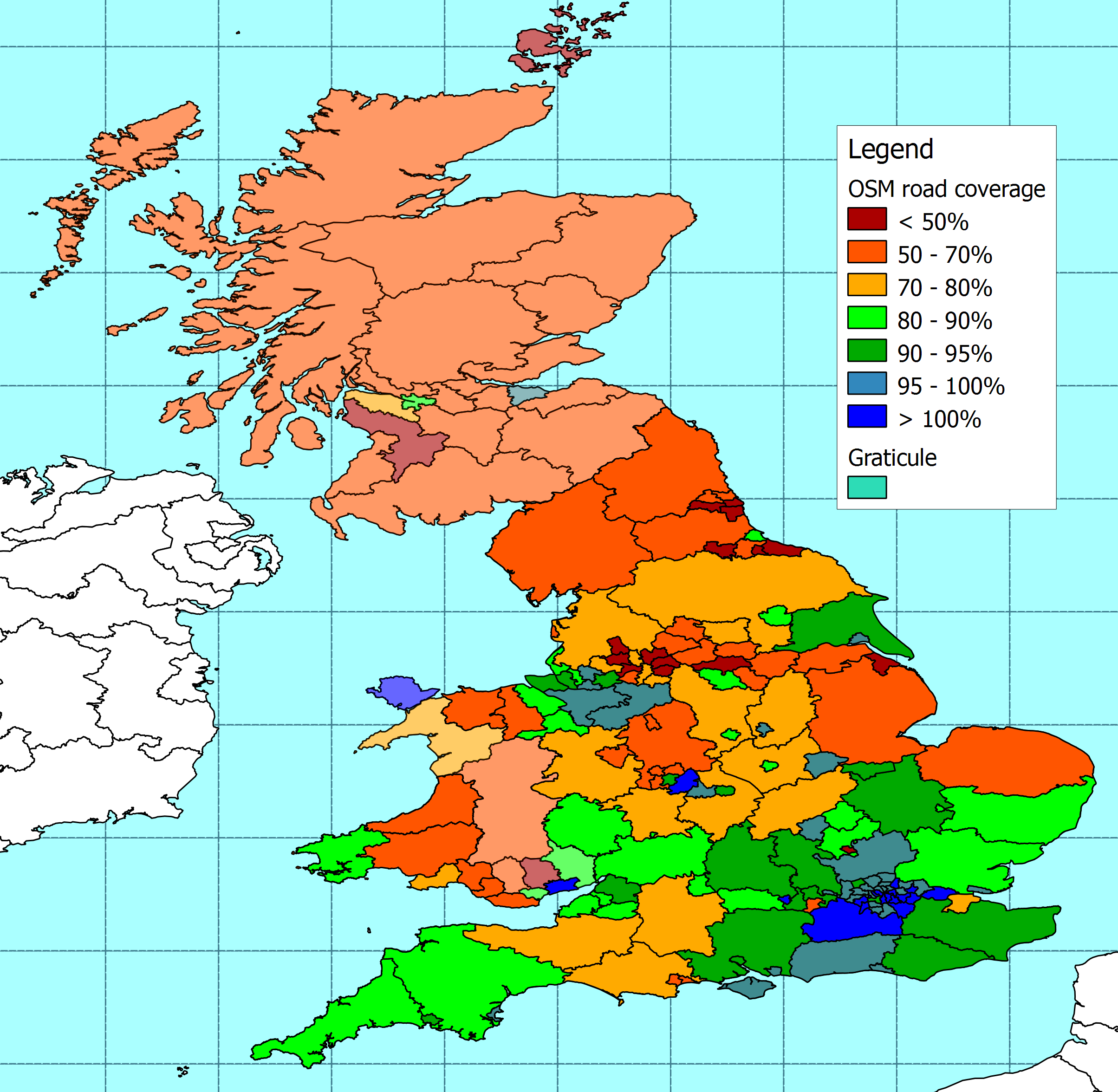
The expanding map of my quest is here

Tuesday 26 January 2010

Transport Direct: cycling routes

I was looking for some information on government contracts today, and stumbled across details of two £1m contracts that the Department for Transport awarded to Landmark Information Group and Cycle City Guides a few days ago. The contracts are to build and maintain a database of cycling data for urban centres in Great Britain. The intent is to support cycle route planning on the Transport Direct web site.

Until then. I hadn't realised that Transport Direct had started offering a cycle route planning service, but I've now given it a try. The existing service looks a bit limited, but I've tried it out on a couple of routes that I am fairly familiar with. It seems to do a decent job, though the Transport Direct user interface has always been a bit clunky.

It's easy to be cynical about these things. On the whole I reckon that Transport Direct does a reasonable job, and I use it fairly often to plan trips that rely on public transport. So I ought to welcome this additional facility, and I imagine that over time they will manage to extend and improve it.

If that seems a bit of a lukewarm reaction, then remember that they have a high standard to live up to. Examples such as Cycle Streets demonstrate just how much can be achieved on what I assume is a much more limited budget. I only hope that in time we will discover that public funding has helped to encourage even more innovation in this area, rather than stifle it.

Sunday 24 January 2010

Marsh Lock, near Henley


No long bike ride this weekend, just a short spin yesterday around one of my favourite local loops around Winter Hill and Cookham. Then today we had a pleasant walk along a very full, and fast flowing river Thames near Henley.

Maybe that's a good enough excuse to demonstrate that I'm making progress with understanding how to overlay OSM with stuff. This is another extract from a Flickr set, but the code underneath the hood shouldn't be wasting quite as many processing cycles as it used to, and it also includes a basic description in the sidebar of the full-sized window. It's not all that nippy, but then it is pulling quite a lot of bits and bobs together.

The beginnings of support for overlaying GPX files are in there too, though that's not apparent in this example. Thanks for all the suggestions and help that got me this far.


The full size version is 'ere

Friday 22 January 2010

Rivendell reader

The homely west-coast nostalgia is a little bit too self-conscious for my taste, but nonetheless, it's packed with content, and worth a look. The "Winter 2010" issue is here.

Monday 18 January 2010

In defence of Slough


Slough is more interesting than most people think.

Here is just one example. The picture shows the Sustrans national cycle route NCN61 as it crosses the M4 at the Langley junction (5). At each end is a corkscrew ramp, followed by a footbridge over the roundabout and a tunnel under the motorway.

I must have driven over and under this hundreds of times without ever noticing such an astonishing creation: until yesterday, when I rode through.


This is how it is rendered on OSM

How exciting is that?

Sunday 17 January 2010

Ordnance at Heathrow


William Roy (1726-1790) spent 1747-1755 mapping Scotland as a civilian working for the army, then joined the army, rising to major-general. In 1763 and 1766, he proposed a 'general Survey of the whole Island at the public cost'. This was seriously considered by the government, but dropped due to the expense. In 1783, he made a small triangulation around Greenwich. In the same year, Cassini de Thury, then Director of the Paris Observatory, suggested the triangulation of southeast England which could be connected to the completed triangulation of northeast France to determine the disputed relative positions of the Paris and Greenwich Observatories. Sir Joseph Banks, proposed that Roy carry out the project and Roy accepted.

The first operation was the laying out of a base line and Roy selected Hounslow Heath as a suitable location, not only for the southeast of England but also with an eye to extending the survey to the rest of the country. Starting on 16 Apr 1784 and continuing through the summer, a length of 27,404.72 feet (about 5 miles) was set out and measured three times - using cased glass tubing made by Ramsden, seasoned deal rods and a coffered steel chain made by Ramsden. The glass tubing was considered to be the most accurate, but the three measurements agreed to within three inches and the steel rods were later adopted as standard.


Sightings from the ends of the baseline to St Ann’s Hill (Chertsey) and Hanger Hill Tower gave another calculated baseline for the triangulations to Severndroog Castle (near Greenwich) and Hundred Acre (Banstead), then quadrilaterals through Frant to Hastings (Fairlight Down), and Hollingbourne Hill (Maidstone) to Allington Knoll and Dover Castle.

The triangulation was completed in 1789. In 1787, the survey had reached the coast and a line was measured on Romney Marsh using Ramsden's steel chain and the measured length agreed with the calculated length to within a foot. Roy had estimated the cost of the triangulation as £1,000, but over £2,000 was spent.

The Hounslow Heath base line was resurveyed in 1791 by Captain Williams, Mudge and Dalby, obtaining a value only 2 inches different and the average was accepted as the basic measurement.

Roy's work led to the foundation of the Ordnance Survey in 1791

In 1791, the original wooden pipes marking the ends of the base line were found to already be decayed and they were replaced by guns buried vertically. Bronze plates were attached to the guns in 1926 to commemorate the bicentenary of Roy's birth. The northwest gun was removed in 1944 due to expansion of Heathrow Airport. It was returned to its original position in 1972. The southeast gun has never been moved and is in Roy Grove, Hampton - grid reference TQ 137709.

The "Principal Triangulation" begun by Roy continued until 1835, but was eventually superseded by a re-triangulation begun in 1935, and completed in 1962. This involved erecting concrete pillars (trig points) on hilltops throughout Great Britain. The re-triangulation was the basis of the British national grid reference system, and new Ordnance Survey maps.

Edited from http://www.dcs.warwick.ac.uk/bshm/zingaz/LondonPeopleN.html#roy, http://www.brlsi.org/proceedvol7/Astronomy200301.htm, and http://en.wikipedia.org/wiki/Retriangulation_of_Great_Britain

Thwarted, but not really


St Anne's at Kew and St Peter's at Petersham (near Richmond) are on my list of famous churches that I want to to visit this year, but they are not next on the list.

However, both can be reached without embarking on a hilly ride through narrow country lanes. So after our recent weather it seemed like a good idea to promote them to next place for this week's ride.

Word association makes Kew and Richmond sound like pleasant places to visit (Kew Gardens, Richmond Park). However, from where we are in the Thames Valley, the obvious routes to get there run through Slough and Staines. Nether of those sounds quite as appealing. Of course both are perfectly good towns, that are no better or worse than hundreds of others. But for a full days ride, I'd rather pick a route that is a bit more interesting. So I spent Saturday evening trying to come up with a plan.

After consulting the authorities, and considering the options, I went to bed with a plan to ride out down Sustrans route 61 along the Jubilee channel to Eton, then on to Heathrow. From there I would shimmy up to the Grand Union Canal, and follow that to Brentford. From there it's a short link over the bridge to Kew. Then I could come back through Petersham along the Thames path and Sustrans route 4.

It was a good plan, and one day I must try it.

Today, it didn't last much further than the first ten miles. In retrospect, the problems should have been obvious. Firstly, the snow has left off-road cycle routes messy, with mud, water and ruts everywhere. Secondly, after weeks of weather everyone and their dog, and their extended family chose today for a walk along the routes that I had carefully picked out.

The result was that progress was incredibly slow. Normally that wouldn't matter too much, but on a 60 mile ride, with a bit of a late start, and a deadline for getting home, I just couldn't afford to do big chunks of mileage at little more than walking pace.

So after Heathrow I battled down a busy A4 to Brentford instead of following the Grand Union Canal. I used the GPS to find a route from Kew to Petersham, and it picked some badly congested main roads. So from Petersham to Teddington I reverted to the Thames path. But again progress was slow, so I gave up at Teddington, and just followed the setting sun west for a fairly direct route home.

As a result my intake of diesel fumes has been higher than intended. That aside, I've had some practice riding in heavy traffic, enjoyed some lovely January weather, seen a couple more churches, met some pleasant people and seen some interesting discoveries on the way. It's been good day - but not quite the one I had planned.

Sunday 10 January 2010

Maidenhead thicket in the snow


No outing on the bike for me this weekend, but a very pleasant walk through the snow yesterday instead. It didn't contribute to my annual cycling goals, but it had its own compensations. Today it has been thawing, but we will see what tomorrow will bring.

Saturday 9 January 2010

Flickr sets and groups on OSM


There are still a few flaws to sort out, but I've figured out how to extract KML files from Flickr groups as well as sets, how to provide either OSM or the Cycle map as a base, and how to embed the results. Results (so far) are below.


Jenkins quest set on OSM


Sustrans coast and castles set on Cycle Map


Sustrans Bristol & Bath group on Cycle Map


(Tues 12 Jan) Now slightly improved to avoid passing the KML file twice and offer alternative base map.

Thursday 7 January 2010

Geotagged Flickr set on OSM Cycle Map

It's a while since I discovered how to show a geotagged Flickr set on Google maps. I think that looks better than Flickr maps, but I've been thinking for a while that it ought to be possible to do the same with the OSM Cycle map as a base.

It's taken me a couple of evenings, but I've now managed to get it working, at least at a basic level. I used Adam Franco's script (here) to automagically generate a KML file from a geotagged Flickr set, then I used OpenLayers to combine that KML file with OSM. The whole shebang is here

Next I would like to generalise it a bit more, so I could do the same with different sets, and it would be better if I knew how to embed a slippy map in a blog post, instead of grabbing an image like I have here.

But as a first attempt I'm quite pleased with it. I know there are lots of people out there who can do this stuff in their sleep, with both hands tied behind their back. But just for now, I'm feeling a bit chuffed that I'm still able to pull this kind of thing together.


There's a slightly enhanced version which can pick up "any" KML file here using my Sustrans Coast & Castles trip as an example.

Tuesday 5 January 2010

Intrepid cycling


Not by me, I should point out, but there are some impressive snowy exploits illustrated on the CTC flickr pool here.

Monday 4 January 2010

OSM cycle map for Garmin


The most common search terms that bring people here are the various permutations of "open", "cycle", "map", and "garmin". So it's only right to pay tribute to all the people who have contributed to the thing that so interests these searchers.

I downloaded the latest version a few days ago, and tried it out yesterday on the way to Ivinghoe and back. There are a few minor glitches, but basically it works fine.

Richard Fairhurst produced the version of the img file I used, and it can be reached here - http://richard.dev.openstreetmap.org/garmin/gmapsupp.img. There are more details here - http://wiki.openstreetmap.org/wiki/OSM_Map_On_Garmin/Cycle_map. There are various alternatives here - http://wiki.openstreetmap.org/wiki/OSM_Map_On_Garmin/Download

This is great work by all involved, and after seeing how grumpy the OSM mailing lists are getting, I hope they all realise that it is very much appreciated.

Sunday 3 January 2010

St Mary the Virgin, Ivinghoe


Saint Mary the Virgin, Ivinghoe is the 35th in my list of churches to visit by bike, and ranks tenth for 2010 - but it is the first one that I have visited this year.

It's a pleasant church ,in a nice village, surrounded by lovely countryside. It took longer to get there than planned, and it was very cold, so I didn't hang around for long. There is some nice carving, the roof is held up by angels, and there is an interesting sign on the back of the door. There is also an old windmill just outside the village.

But the point of all this is isn't sight-seeing. It's really about setting myself the challenge of reaching destinations that are further and further away. Each time I reach another church on my list, it means that the next one is a bit further away. Today it meant a round trip of 63 miles on the bike, in glorious sunny, but very cold winter's weather. I got a good day's exercise, and as normal I got to explore some countryside that I wouldn't otherwise think of visiting.

The busier roads were clear enough, but the little country lanes were icy where the sun hadn't reached them. That made for some interesting moments, but I only went over once. I did chose a slightly different route back though, to avoid riding on icy lanes in the dark.

The way there and back is fairly hilly - it's in the Chilterns, after all. To be frank, it probably wasn't a good idea to be quite so ambitious on a cold day after a long break. By the time I got home I was over-tired, pretty sore, and more than ready for a hearty dinner. But without doubt it was worth it. I've ticked off one church, and one ride of more than 60 miles towards my annual goals and the weekly mileage is ahead of plan. And I enjoyed myself.

Saturday 2 January 2010

OSM coverage


A few months ago I compared the length of roads on the OSM database against the figures quoted by the Department for Transport. I've now updated the analysis using an OSM database extract from the end of 2009. The resulting map is here and the data from the analysis is here. The DfT data can be found here.

In summary, the length of UK roads on OSM has increased by around 5% over the last few months. The south east of England is still generally better covered than the north, but there is improved coverage all over the place.

The biggest increase in coverage is in Cornwall, which has moved from less than 50% coverage to more than 80%. There are also significant improvements in Plymouth, and a number of cities in northern England and the West Midlands.

It's quite nice to feel I have contributed to some improvement around here, but much more impressive to see things moving forward across the rest of the country.

Friday 1 January 2010

Jenkins 2010

These are the 15 churches in my list of destinations for this year, ranked by distance as the crow flies.

Fortuitously, CycleStreets has extended the limit of its route planning in the last few days, so I can use it for some good route ideas.

All I have to do now is the cycling.