Friday, 31 July 2009
Tuesday, 28 July 2009
Estimating OSM UK Coverage
I still can't make this work for all local authorities. That's partly because the data is incomplete, and partly because of mistakes in the way I have collated the data. However, thanks to help from the Talk-GB list, I am begining to get plausible figures for quite a lot of England and some bits of Wales.
It's an interesting exercise - I am learning a lot about Postgresql databases and the Postgis extensions. I haven't finished. There is still work needed to plug the gaps and improve the accuracy, and better examples to aspire to, like this. But I thought an initial view might be timely, even though it is incomplete.
Anyone who hasn't booked their holidays yet can already see that there is work needed on the map in Cornwall, and quite a bit in Cumbria, Northumberland and Norfolk. And Bracknell.
Saturday, 25 July 2009
Seer Green revisited
It's been a demanding week, so I just wanted a straightforward ride this afternoon. Nothing too ambitious.
I settled on riding to Seer Green, to plug the gaps remaining in OSM.
Last time I went there was about a month ago. At the time I mapped quite a lot of the village, but I missed a few bits. Today I think I have plugged most of the gaps - at least as far as capturing the road system, which is my main interest.
More importantly I had a really good ride out and back. The weather was quite warm, but not unbearable. I know the roads reasonably well, and I managed to stay on fairly quiet lanes, except for mucking up badly near Beaconsfield, and ending up negotiating a major roundabout on a junction of the M40.
This time, like last, I covered just over 30 miles. As a result, once again, the next gap on the map is now just a litlle bit further away.
Tuesday, 21 July 2009
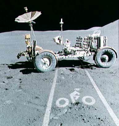
Bike lane violations
The examples posted here are getting increasingly absurd, but they are certaibly amusing.
I have no right to quibble, but it might be worth adding that the real problem is one of quantity. Highlighting amusing examples makes an effective point, and is certainly entertaining, but slightly misses the mark.
Saturday, 18 July 2009
Red and blue ears
On my train journey back from Winchester I used the Virgin cross-country train. I needed to get a ticket for the bike. Which was a bit of a pain, for me and those behind me in the queue - but no matter.
Also there was some confusion about where bikes are supposed to go (coach F if there is no buffet cart, and coach D if there is, apparently). But that's still not the most important issue.
What really puzzles me is why most of the seats on one side of the carriage have a blue ear, and most on the other have a red ear?
I did wonder if this was so that the directionally challenged knew which way the train was travelling, but then I noticed a few seats at the end with the ears the other way round, so it can't be that.
Perhaps it's a way of segregating passengers to avoid political arguments. All the Telegraph readers on one side, and Guardian readers on the other. Is it significant that several of the passengers with blue ears are bald?
Swithun's revenge
It was Saint Swithun's day on Wednesday. Legend says that if it rains on St Swithun's day it will rain for 40 days.
It did rain on St Swithun's day this year, but the forecast for today was OK. So it seemed appropriate to celebrate with a ride to Winchester, where Swithun was bishop from 852-862, and where he is buried.
It was quite a long ride out (63 miles) and I caught the train back. Until about 15 miles from Winchester the weather was OK, but for the last hour it rained steadily, which put a bit of a damper on what had previously been a lovely day.
I've now managed to figure out quite a pleasant route from home to Beech Hill, avoiding the busy areas around Wokingham and Reading. From there I picked up National Cycle Route 23, which took me through Basingstoke to Alresford. All very pleasant, and NCR23 weaves quite a clever route through Basingstoke, but it was a particularly enjoyable ride from south of Basingstoke to near Alresford.
But by then, the tradition of Swithun had come true, and the weather turned from sunny to very wet. So in the end I just took the direct route from Alresford into Winchester. Despite cutting things shorter than planned I still arrived much later than I had intended. I decided not to look around Winchester in the rain. I like the place, but if I had wanted to visit there would have been easier and quicker ways to get there.
Most of my route is already plotted on OSM, but I've traced a few short sections which will fill gaps. But the real point of the day was the ride, which I thoroughly enjoyed. A shame about St Swithun though.
St Swithun's day if thou dost rain
For forty days it will remain
St Swithun's day if thou be fair
For forty days 'twill rain no more
It did rain on St Swithun's day this year, but the forecast for today was OK. So it seemed appropriate to celebrate with a ride to Winchester, where Swithun was bishop from 852-862, and where he is buried.
It was quite a long ride out (63 miles) and I caught the train back. Until about 15 miles from Winchester the weather was OK, but for the last hour it rained steadily, which put a bit of a damper on what had previously been a lovely day.
I've now managed to figure out quite a pleasant route from home to Beech Hill, avoiding the busy areas around Wokingham and Reading. From there I picked up National Cycle Route 23, which took me through Basingstoke to Alresford. All very pleasant, and NCR23 weaves quite a clever route through Basingstoke, but it was a particularly enjoyable ride from south of Basingstoke to near Alresford.
But by then, the tradition of Swithun had come true, and the weather turned from sunny to very wet. So in the end I just took the direct route from Alresford into Winchester. Despite cutting things shorter than planned I still arrived much later than I had intended. I decided not to look around Winchester in the rain. I like the place, but if I had wanted to visit there would have been easier and quicker ways to get there.
Most of my route is already plotted on OSM, but I've traced a few short sections which will fill gaps. But the real point of the day was the ride, which I thoroughly enjoyed. A shame about St Swithun though.
Sunday, 12 July 2009
New bar ends
Today I rode out to the local bike shop and bought new bar ends. I fitted them when I got home, and I've tried them out briefly. They seem pretty good, but it will take a long ride to see how they really work out.
I like the lizards though.
Saturday, 11 July 2009
They practice beforehand
On my way home this evening I touched more than 35 mph with a following wind on the long 1:10 slope down from Beaconsfield into Wooburn Green. I caught myself braking as I approached the speed limit sign. That's pretty exhilarating stuff for me.
Then I found this. How do they do that?
Jordans
Last week I was talking with someone about a town in Poland, which he described as "very nice, but there's no reason for anyone to visit". He left me curious to go and have a look.
In a slightly different vein, we live about 12 miles away from Jordans, which is well known for the 17th century Quaker meeting house. Before it was built meetings were held in Jordans farm. In 1687 the "Declaration of Indulgence" allowed the friends to build a meeting house, and the building we see today was erected in six weeks.
By 1915 there was a fear that surrounding land would be sold to a speculative builder, and to preserve the Quaker heritage, a Village Estate was established at Jordans to support a community of craftsmen based on Christian principles.
Jordans Village Industries laid out the village in 1919, and began building using its own industries to produce the materials, but in 1923 it was forced to go into liquidation. The community never achieved the scale of the original plans, but development has continued and Jordans Village Ltd now owns and rents out some of the flats, cottages, and houses. Other property in the village is privately owned, but contributes to communal amenities.
The village was only partially mapped on OSM, and I was curious to take a look at a 20th century village that was created to preserve 17th century heritage.
Pevsner seems to like the place, though he comments that the architect preferred style over convenience. As best as I could tell by riding around it seems very pleasant indeed.
The Meeting house is an important historical building, and well worth a visit for that. There's no real reason to go and see the village, though - and I suspect that it's all the better as a result.
Thursday, 9 July 2009
Quote
"Sometimes when you are in the dressing room before going on, you look around and think 'There's Mick, there's Charlie, there's Ron. All right?... There's me. And you suddenly think, Is that all there is? Where's the one that knows everything?" Keith Richards 1994. Lifted from "Stone Me, the Wit and Wisdom of Keith Richards, by Mark Blake.
I've got a teleconference scheduled for tomorrow that's going to be just like that.
Wednesday, 8 July 2009
Arthur Stanley Eddington
John Butler has kindly sent me a couple of scans from a cycling guide that used to belong to Arthur Stanley Eddington. His parents found it when they moved into Eddington's old house in Cambridge.
Quite apart from the connection with a famous man, the books themselves look as though they would be interesting. I see that is is possible to download a scan from the Internet Archive of the full "Contour Road book" for Northern England from 1897 here (not Eddington's copy, though!), and for Western England (which seems to include Wales) here. Scotland is here. There was another covering South East England, but I haven't found a full scan of it yet.
My original post is here and there is more about Eddington on Wikipedia here. Many thanks to John.
Monday, 6 July 2009
When possible execute a U-turn
Richard Fairhurst has provided a routable OSM cycle map for Garmin GPS, which I downloaded from here yesterday. This evening I've been out on the bike to give it a try. And I'm suitably impressed.
There seem to be a few glitches, but the only real problem was that I had to remember to keep my attention on the traffic, rather than getting too interested in watching it count down to the next junction.
The mapping is very clear, the routes that it found seemed pretty sensible, and the directions are easy to follow.
It can search for addresses, but I just stuck a virtual pin in the map about six miles from home. Then I let it guide me there step by step, then reversed the process to come home again. Naturally, I also did the mandatory bit of stubbornly refusing to follow instructions, and forcing re-calculations.
It only took a few seconds to work out the route, though when I chose somewhere further away it took a lot longer, and sometimes seemed to lock up altogether.
Most of the time it describes each junction accurately, but it sometimes seems to imagine a roundabout where there isn't one (either on the ground or in the map). I thought it was failing to recognise the names of some minor roads, but on checking that's because they are not named in the map.
I could have made good use of this a few weeks ago when I was trying to find my way through Stanmore, and I'm sure it's going to prove useful in future. But what has really impressed me is how much things have moved on since I first came across all this stuff about 18 months ago. If you haven't tried this out, then I'd encourage you to experiment, and join me in thanking all those who are contributing tools and content.
And so to work...
- John Sawyers goes to the beach
- John Sawyers wife puts pictures on Facebook of John Sawyers on the beach
- Mail on Sunday outraged about pictures on Facebook of John Sawyers on the beach
- Andrew Marr interviews Foreign Secretary about pictures on Facebook of John Sawyers on the beach
- Guardian publishes editorial on Mail and BBC coverage of pictures on Facebook of John Sawyers on the beach
- Tlatet points out Guardian editorial on Mail and BBC coverage of pictures on Facebook of John Sawyers on the beach
Would anybody care to comment further, or have we all found more interesting ways to spend our lives?
Saturday, 4 July 2009
Pendon Museum & Didcot
For the last few months most of my longer weekend rides have aimed to reach a church on the list for my 2009 Jenkin's quest. My own rules demand that I cycle there and back, without using public transport. But now that I have completed the planned list for this year I am free to try other destinations, under different rules.
It has been so hot over the last week that I've wimped out, and not ridden the bike for several days. Today was cooler, and I wanted to cover a reasonable distance, without going too far. It seemed like a good idea to have a bit of a change for the destination.
I decided I would ride to Didcot, and get the train back, without much of an idea why, or what to do on the way.
On the way out I rode through Henley, which was crowded with visitors in blazers and posh frocks for the regatta (some in blazers, and some in frocks - none as far as I could see in both). Then I went through Stoke Row, where the Maharajah's well has been spruced up.
From there I followed National Cycle Route 5 through Wallingford, to Didcot. I hadn't realised it, but this route passes the Pendon model railway museum at Long Wittenham. So I stopped there for a look at the amazingly detailed models and recall one of the hobbies of my childhood. With another visit to the Didcot Railway Centre before catching the train home, it turned out to be a bit of a railway oriented trip.
I traced my route with the GPS, but I don't think there will be much to add to the Open Street Map. As far as the weather was concerned, I saw a bit of light rain between Stoke Row and Wallingford, but the day was mostly warm, with clouds clearing to blue sky later in the day.
Queuing with all the traffic in Henley was a bit of a pain, which I could have avoided if I had thought a but more carefully about the route. On the whole, though, it was a very pleasant day out. A bit different to my normal pattern, and none the worse for that.
Wednesday, 1 July 2009
Cycle lanes
A couple of weeks ago, on my trip to Stanmore, I ended up following some of the cycle routes in North London. For many of these, they have marked off a fairly wide strip of the main road, and designated it as a cycle lane.
In theory that seems like a good idea, but in practice it wasn't a very comfortable experience. That's largely because of the number of cars that were parked in the cycle lane. They regularly forced me to execute a tricky manouvre in order to switch from the cycle lane into the main carriageway.
As it was a Sunday, the traffic wasn't too heavy, but any cars on the road were still moving fairly quickly. On a weekday I imagine it would be busier, but perhaps there are fewer parked cars.
The Department for Transport recognises the problem. Their "Manual for Streets" says "Cyclists should be catered for on the road if at all practicable. If cycle lanes are installed, measures should be taken to prevent them from being blocked by parked vehicles."
I hadn't paid much attention to cycle lanes before, because the ones near home are few and far between, and they are only narrow. They are not quite as narrow as this one in Liverpool that the Warrington Cycle Campaign has (rightly) singled out for public humiliation. But they are narrow enough to be pretty irrelevant.
Being offered a broad cycle lane that was then being used as a car park was much more annoying. I couldn't stay in the cycle lane, because there were so many parked cars. If I stayed outside the parked cars I was blocking one of the two lanes that were left for cars to use, and if I swerved in and out of the gaps I was repeatedly at risk of losing an argument with something big and heavy and fast.
At the time I imagined that urban cyclists must have mastered some mysterious technique that we humble country folk from the Thames valley know nothing of.
Having read what John Franklin says in Cyclecraft I have come to a different conclusion. He says "narrow lanes... .have led to some very difficult conditions for cycling". Quite apart from the problem of obstructions, he points out that they restrict the movements of cyclists, encourage cyclists to ride too far to the left, and few cycle lanes allow for correct positioning at junctions. They are mis-interpreted by motorists, encouraging them to overtake cyclists too closely, and they lead to resentment and hostility when cyclists have to ride outside the lane.
I'm paraphrasing here, but as far as I can see, he basically recommends that cyclists ignore cycle lanes. We should ride where we believe it is safest to ride, while watching out for motorists mis-reading our position.
As usual with his advice, that seems to make a lot of sense.
I'm still not sure about condemning cycle lanes though. For myself I am getting more confident about chosing and signalling my position and intended direction, so I'm more comfortable about sharing the road with cars than I used to be. But it has taken me a couple of years and quite a lot of miles to get to this level of confidence. A bit of help separating cyclists and cars doesn't seem like such a bad idea. I certainly don't want to blame the road engineers who put in nice wide cycle lanes. It's the idiots who park in them (and, for that matter, on pavements) who really get my dander up.
Subscribe to:
Posts (Atom)