A couple of months ago I was regularly picking out a local village or estate that hadn't been mapped, and using that as an excuse for an evening ride. But as the amount of detail on the map builds up, there are fewer blank areas within easy reach of home, and even on longer trips I keep discovering that somebody else has already plotted the main roads.
I haven't completely stopped adding details. Sometimes I come across a road that hasn't been plotted before, or that has only been plotted roughly, but I need to get myself better organised if I'm going to be more useful.
Various good people have put together the tools to build and transfer OSM cycle maps to a Garmin GPS system. The maps themselves can be downloaded here. But it has been about three months since the downloadable UK maps have been updated.
So it seemed like a good idea to use the tools and produce my own version of the map.
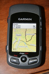
I'm reasonably proficient with software, but it took a bit of trial and error to make it all work. To be honest, that is not so much a problem with the tools. It's really because I tend to rush into trying things out without reading the instructions properly. In any case, as the picture shows, I got it all working before too long, and now my GPS contains what seems to be a complete OSM cycle map of the UK.
So far I have used the default settings, but if I understand it right, there are lots of options that I can play with to change the format.
The met office are promising better weather tomorrow. If they are right I will go for a ride. But if they are mistaken, and we have another stormy evening, then I can always sit at home in the dry and twiddle.
2 comments:
Yeah, I didn't get round to automating them, and nobody has complained up until now :-) Since I'm mainly using the nonames garmin maps from http://downloads.cloudmade.com I haven't been making the UK ones for myself recently.
If anyone wants them, just poke me and I can recreate them - I'm doing an update for last weeks ones now!
This must now be at the point where it is useful to a lot of people beyond those who are interested in the tools, or the map data itself.
It needs a bit of determination and previous knowledge to roll your own IMG file, and I suspect there is quite a number of silent people out there who would appreciate a new version periodically to pick up the latest updates.
So this wasn't meant as a complaint at all. It's not as if you are under any obligation to me! In any case I ended up learning a bit more about how all these things hang together - which was interesting in itself.
Post a Comment