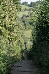
The route is well signed on the ground, but it took some finding on a map. As far as I can tell, the only place it has been published on the interweb is in a fairly obscure Buckinghamshire transport strategy document. Which is odd, because it is a fine route through lovely countryside, with a choice of good places to stop off on the way. Whoever first laid it out had a good eye for landscape, but unfortunately either they had a bit of a blind spot for hills, or a wicked sense of humour, because there are some pretty challenging climbs, including this steep farm track linking a couple of roads north of Marlow.
I traced the route on the GPS, and I've tagged it on Open Streetmap, so it will appear towards then end of this week when the cycle map is re-generated. But regular visitors to Tlatet, will, I am sure, have an urgent need for more detail.
So here we go. In outline the route climbs to the north of Marlow, as far as Frieth, then turns west, through Fingest, and south through Hambleden. In the past I've taken the road through Bovingdon Green out of Marlow, and the A4155 from Hambleden back, but this route starts out along the B482 on the way out, and on the return uses narrow lanes to climb through Rotten Row to Marlow Common, before dropping back into Marlow. It also takes a slightly different back route through Hambleden.
As far as the fauna goes, the highlights today were a small deer that crossed the road about 100 yards in front of me; and a number of large birds of prey, flying low across the road - presumably searching for small rodents in the fields.
When I reached Hambleden, at about 4pm there was a choral concert in the church, and they were serving tea and cakes in the churchyard. I joined a small group sitting outside in the sun, listening to the music through the windows. I'm not a great tea drinker, and the best I can say about the coffee was that it was warm, brown, and wet; but the selection of cakes was awesome. I finally settled for some cinammon flapjack - which was delicious - but it was a tough choice.
By the time I had made my way to Marlow and home, the whole ride turned out to be just over 30 miles (the loop itself is about 15 miles from Marlow and back).
Next time I can't rely on such a lovely afternoon, and cakes in Hambleden churchyard, but I'll be back, because this is one of the best routes that I've found at around that length. Next time I might even manage to do a bit better on the steep hills. There are plenty of good places to stop for a break; and it looks to be popular with cyclists (several passed me on the hills). So it seems odd that the route isn't named and publicised more widely.
Or perhaps I've missed something. If so, please let me know.
4 comments:
all the best rides come with cake.
The deer was probably a muntjac, round your neck of the woods.
Tea and cake in the churchyard! Stop it, you're making me all nostalgic for things lost.
We actually did this route about 3 weeks ago. I was attemting to follow parts of the 100kM AMR Chiltern route, so we started in Freith with the intention of cycling as far as North End, then making our own way down to Hambledon, to pick up the route again, back to Freith via Marlow Common. So apart from your last mile or so into to Hambledon, and the bits to and from Marlow, we covered the same route.
Funny enough I started to follow the cycle signs after Hambledon, and assumed that there were connected the 100kM route, but realised that this was not the case when I realised we were lost just before Marlow Common.
It's a very senic ride, the area is very rural, for being so close to several large towns. Though we seemed to spend a lot of time walking our bikes up the hills!
t
Thanks for the comment, anonymous. I agree with your comments on the route, and it's good to know that I am not the only one defeated by some of the hills.
FWIW, the route I tagged has now appeared on the OSM cycle map. Apart form the bit I missed!
Post a Comment