Saturday, 9 January 2010

Flickr sets and groups on OSM


There are still a few flaws to sort out, but I've figured out how to extract KML files from Flickr groups as well as sets, how to provide either OSM or the Cycle map as a base, and how to embed the results. Results (so far) are below.


Jenkins quest set on OSM


Sustrans coast and castles set on Cycle Map


Sustrans Bristol & Bath group on Cycle Map


(Tues 12 Jan) Now slightly improved to avoid passing the KML file twice and offer alternative base map.

Thursday, 7 January 2010

Geotagged Flickr set on OSM Cycle Map

It's a while since I discovered how to show a geotagged Flickr set on Google maps. I think that looks better than Flickr maps, but I've been thinking for a while that it ought to be possible to do the same with the OSM Cycle map as a base.

It's taken me a couple of evenings, but I've now managed to get it working, at least at a basic level. I used Adam Franco's script (here) to automagically generate a KML file from a geotagged Flickr set, then I used OpenLayers to combine that KML file with OSM. The whole shebang is here

Next I would like to generalise it a bit more, so I could do the same with different sets, and it would be better if I knew how to embed a slippy map in a blog post, instead of grabbing an image like I have here.

But as a first attempt I'm quite pleased with it. I know there are lots of people out there who can do this stuff in their sleep, with both hands tied behind their back. But just for now, I'm feeling a bit chuffed that I'm still able to pull this kind of thing together.


There's a slightly enhanced version which can pick up "any" KML file here using my Sustrans Coast & Castles trip as an example.

Tuesday, 5 January 2010

Intrepid cycling


Not by me, I should point out, but there are some impressive snowy exploits illustrated on the CTC flickr pool here.

Monday, 4 January 2010

OSM cycle map for Garmin


The most common search terms that bring people here are the various permutations of "open", "cycle", "map", and "garmin". So it's only right to pay tribute to all the people who have contributed to the thing that so interests these searchers.

I downloaded the latest version a few days ago, and tried it out yesterday on the way to Ivinghoe and back. There are a few minor glitches, but basically it works fine.

Richard Fairhurst produced the version of the img file I used, and it can be reached here - http://richard.dev.openstreetmap.org/garmin/gmapsupp.img. There are more details here - http://wiki.openstreetmap.org/wiki/OSM_Map_On_Garmin/Cycle_map. There are various alternatives here - http://wiki.openstreetmap.org/wiki/OSM_Map_On_Garmin/Download

This is great work by all involved, and after seeing how grumpy the OSM mailing lists are getting, I hope they all realise that it is very much appreciated.

Sunday, 3 January 2010

St Mary the Virgin, Ivinghoe


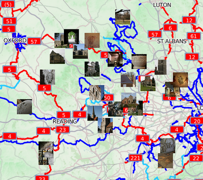
Saint Mary the Virgin, Ivinghoe is the 35th in my list of churches to visit by bike, and ranks tenth for 2010 - but it is the first one that I have visited this year.

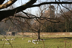
It's a pleasant church ,in a nice village, surrounded by lovely countryside. It took longer to get there than planned, and it was very cold, so I didn't hang around for long. There is some nice carving, the roof is held up by angels, and there is an interesting sign on the back of the door. There is also an old windmill just outside the village.

But the point of all this is isn't sight-seeing. It's really about setting myself the challenge of reaching destinations that are further and further away. Each time I reach another church on my list, it means that the next one is a bit further away. Today it meant a round trip of 63 miles on the bike, in glorious sunny, but very cold winter's weather. I got a good day's exercise, and as normal I got to explore some countryside that I wouldn't otherwise think of visiting.

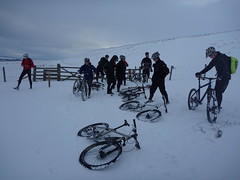
The busier roads were clear enough, but the little country lanes were icy where the sun hadn't reached them. That made for some interesting moments, but I only went over once. I did chose a slightly different route back though, to avoid riding on icy lanes in the dark.

The way there and back is fairly hilly - it's in the Chilterns, after all. To be frank, it probably wasn't a good idea to be quite so ambitious on a cold day after a long break. By the time I got home I was over-tired, pretty sore, and more than ready for a hearty dinner. But without doubt it was worth it. I've ticked off one church, and one ride of more than 60 miles towards my annual goals and the weekly mileage is ahead of plan. And I enjoyed myself.

Saturday, 2 January 2010

OSM coverage


A few months ago I compared the length of roads on the OSM database against the figures quoted by the Department for Transport. I've now updated the analysis using an OSM database extract from the end of 2009. The resulting map is here and the data from the analysis is here. The DfT data can be found here.

In summary, the length of UK roads on OSM has increased by around 5% over the last few months. The south east of England is still generally better covered than the north, but there is improved coverage all over the place.

The biggest increase in coverage is in Cornwall, which has moved from less than 50% coverage to more than 80%. There are also significant improvements in Plymouth, and a number of cities in northern England and the West Midlands.

It's quite nice to feel I have contributed to some improvement around here, but much more impressive to see things moving forward across the rest of the country.

Friday, 1 January 2010

Jenkins 2010

These are the 15 churches in my list of destinations for this year, ranked by distance as the crow flies.

Fortuitously, CycleStreets has extended the limit of its route planning in the last few days, so I can use it for some good route ideas.

All I have to do now is the cycling.