Saturday, 29 August 2009

Saint Pancras

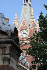
St Pancras Station, clock tower
I had a meeting in King's Cross this week, and afterwards I dragged my colleagues round to Saint Pancras for a coffee. At the time it was built such Victorian archtecture was considered brash and vulgar - a bit of a mishmash of styles. Now it is widely regarded as a masterpiece. While I'm not sure my colleagues agreed, I think it is a delight, they've done a wonderful job of the restoration and it's well worth a walk round the block for an eyeful.

I was reminded of this today because I've been back to Ascot, Sunninghill and Sunningdale to fill more gaps in Open Street Map. Each of these neighbouring towns has quite a pleasant Victorian village at its core, and an interesting mix of housing, but they are also surrounded by endless estates of enormous and expensive looking new houses. I like the older bits, but I'm afraid I find a lot of the recent building grotesque. Oddly they seem to have fenced most of the residents in with huge railings and locked gates.

One day, perhaps, people will look back at this in the same way as we now look at Saint Pancras, and make diversions to look at a remarkable collection of 21st century domestic compounds. But somehow I doubt it.

I know that I've not managed to get all the roads traced that were missing from the map, but I think I've now got a pretty fair proportion. It was a good day for a ride, but I found some of it a bit depressing, and I won't be rushing back.

Friday, 28 August 2009

Wired


Wired have used my photo of an OSM cycle map on my Garmin to illustrate a recent article. The link is here. It's not a bad article.

I quite like Wired, so I am hugely flattered that they chose my picture, and pleased that they have attributed it. But I'm a bit surprised that a publication like that didn't take more care over the license restrictions, which specify "non-commercial use".

I've emailed them to that effect, offering to send details of where to send payment, if only in recognition of the importance of the licensing system, and the rights of commercial photographers. I will report results.

Sunday, 23 August 2009

Arbitrary and meaningless?

A comment on the OSM Talk-GB lists has got me thinking. It was part of discussion on creating local "chapters" to represent OSM. That's not a subject that particularly interests me, and the comment was a bit of a sideline to the main thread anyway. But I was struck by the thought that such chapters should be organised around "real" regions, not "arbitrary" and "meaningless" government boundaries.

The connection is that I've been closing some of the gaps in the local government boundaries to make my estimates of OSM coverage work. Chasing down the gaps showed just how many different paths the boundaries follow. Most often they track some feature in the landscape: usually a river or a stream. Many follow parts of the transport infrastructure, including a lot of roads and some railways (some follow the path of a railway that is no longer there). Near to where I was mapping yesterday part of the boundary for Bracknell Forest (council created 35 years ago) follows the path of a Roman Road (laid out 2,000 years ago). Some boundaries seem to have been adjusted to surround new housing developments, or follow more recent infrastructure such as a motorway. Others just snake across the countryside, following a route that has no apparent rationale at all.

It certainly ends up looking a bit mad. But of course it isn't really arbitrary or meaningless. It's the result of a whole series of decisions that date back at least to Saxon times (for shire counties), and medieval times (for towns). More recently there have been a couple of hundred years of trying to reform all this, and adapt to the effect of the industrial revolution and subsequent change. Right up to the creation of new unitaries earlier this year. At the time, each individual decision must have made some kind of sense, even if they now look arbitrary and meaningless to our eyes.

I am getting to the age when I ought to start grumbling about everything going to the dogs, but I don't have much sympathy with the view that local authorities have to be preserved as part of our national heritage. They are there to serve a practical purpose, not a ceremonial one. Like language they have to adapt to changing needs. And I doubt many of the existing boundaries have had any kind of democratic basis. Existing structures have pretty much been imposed on us: by power struggles between modern politicians, Victorian industrialists, Medieval bishops, Norman lords, Saxon Earls, and even Roman soldiers.

No doubt when the Martians invade they will impose new and more "rational" boundaries on us - just as the Normans did to the Saxons, and just as Napoleon did to much of Europe a couple of hundred years ago. Drawing up new boundaries is a neat way to break up an existing power base.

Certainly a few lines on the map are never going to reflect all the different "real" geographies out there, and "English administrative boundaries: the first 2,000 years" is unlikely to make the best-seller lists. But the boundaries we have today carry all the mess and inconsistency of their history. That's not a reason to preserve them, but until the Martians arrive, I reckon we ought to celebrate it.

Saturday, 22 August 2009

A day at Ascot

I estimate that about 80km of roads in my local authority (Windsor & Maidenhead) have not yet been added to Open Street Map. In comparison to other places in England that's not too bad - 89% of roads are already there. But compared to some other parts of South-east England it looks a bit thin.

The issue of course, is to find the missing roads, trace them, and get them added. Some of them are isolated gaps, and those are going to take the most effort to reach and trace. But there are also some areas with a bit of a cluster of missing roads. In this part of the world, the residential areas around Ascot and Sunninghill look like the best opportunity to do some useful mapping without chasing around all over the place.

It took a couple of hours riding to get out there, but in the process I managed to plot a few of the isolated gaps. I did the same on the way back, but the bulk of the afternoon was looping around an interesting mix of different residential areas. I reckon I've managed to trace a reasonable proportion of what was missing from the bottom right-hand corner of the Windsor & Maidenhead authority, and I'm all geared up to add them to OSM. Unfortunately it's down for maintenance this weekend, so I will just have to wait.

Friday, 21 August 2009

OSM coverage in Scotland and Wales

Name |Coverage
Isle of Anglesey | 124%
Gwynedd | 71%
Conwy and Denbighshire | 54%
South West Wales | 60%
Central Valleys | 43%
Gwent Valleys | 35%
Bridgend and Neath Port Talbot | 65%
Swansea | 77%
Monmouthshire and Newport | 72%
Cardiff and Vale of Glamorgan | 79%
Flintshire and Wrexham | 87%
Powys | 50%


Angus and Dundee City | 56%
Clackmannanshire and Fife | 51%
East Lothian and Midlothian | 65%
Scottish Borders | 60%
Edinburgh, City of | 99%
Falkirk | 55%
Perth & Kinross and Stirling | 66%
West Lothian | 64%
East Dunbartonshire, West Dunbartonshire and Helensburgh & Lomond | 66%
Dumfries & Galloway | 51%
East Ayrshire and North Ayrshire mainland | 42%
Glasgow City | 86%
Inverclyde, East Renfrewshire and Renfrewshire | 70%
North Lanarkshire | 55%
South Ayrshire | 48%
South Lanarkshire | 58%
Aberdeen City and Aberdeenshire | 46%
Caithness & Sutherland and Ross & Cromarty | 64% *
Inverness & Nairn and Moray, Badenoch & Strathspey | 64% *
Lochaber, Skye & Lochalsh, Arran & Cumbrae and Argyll & Bute | 64% *
Eilean Siar (Western Isles) | 67%
Orkney Islands | 29%
Shetland Islands | 48%

(*) = Average across three regions

Coverage = (length of roads plotted in OSM across the region) / (DfT figures for the length of road in the local authorities that make up the region)

Thursday, 20 August 2009

OSM coverage in Scotand and Wales


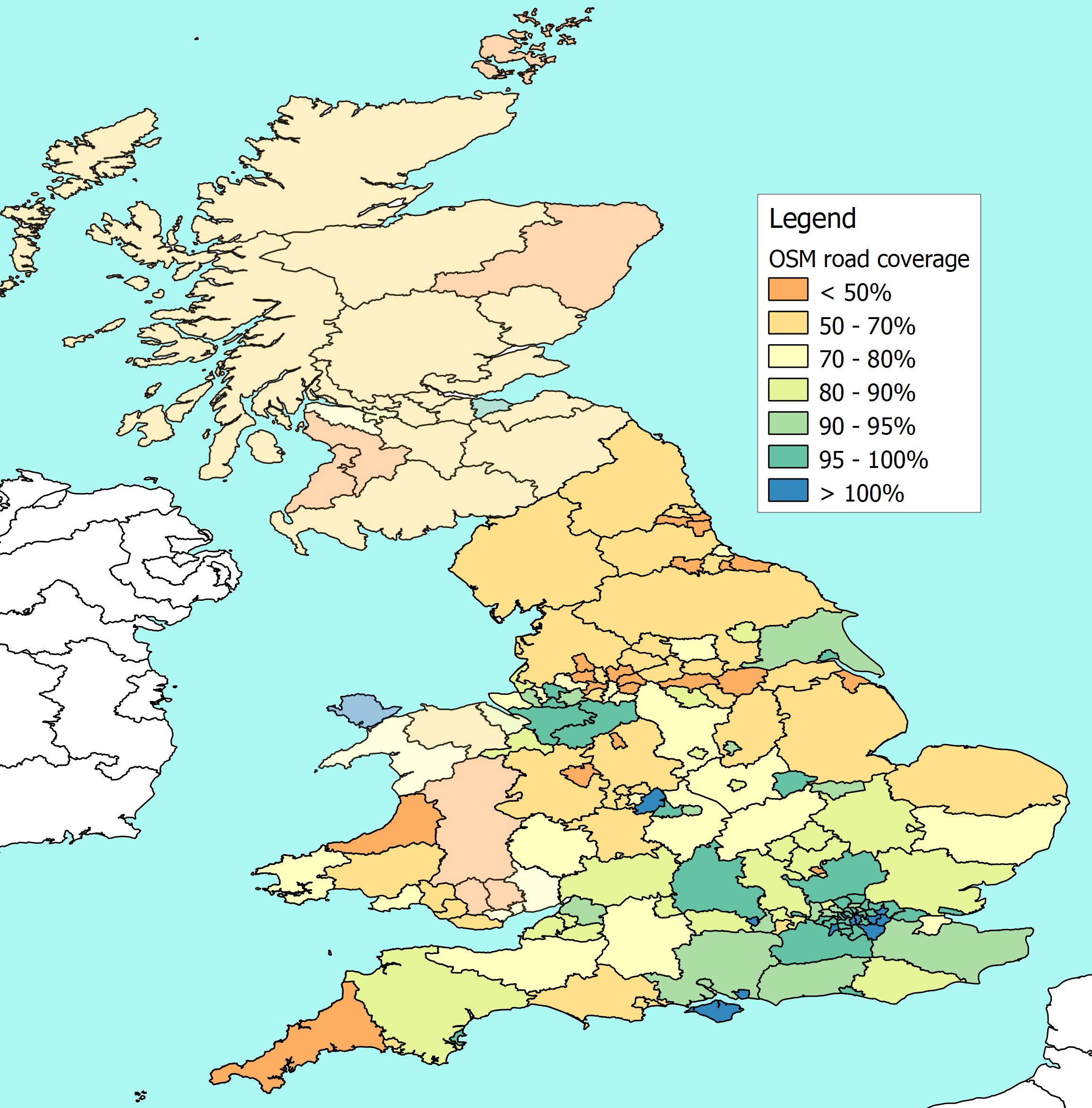
I've had a first attempt at measuring OSM coverage in Scotland and Wales using NUTS-3 regional boundaries as the common ground to compare Department for Transport statistics on the length of roads in a local authority against the length of roads plotted on OSM.

NUTS is the basis on which the EU publish regional statistics, and they provide the boundaries as shapefiles. The precision isn't as great as you get from admin boundaries on OSM, so this is a stop-gap until the boundaries for local authorities in Scotand and Wales are complete on OSM (or until the Ordnance Survey put them in the public domain).

On the whole the NUTS boundaries match up reasonably well with Local Authority boundaries. In some cases they are the same, in others I can aggregate the road lengths for a few authorities to get the figure for the equivalent NUTS region. It's only in the Scottish highlands where this doesn't work too well, because the local authority for the Highlands crosses several NUTS regions. So I needed to take an average across a big area of northern Scotland.

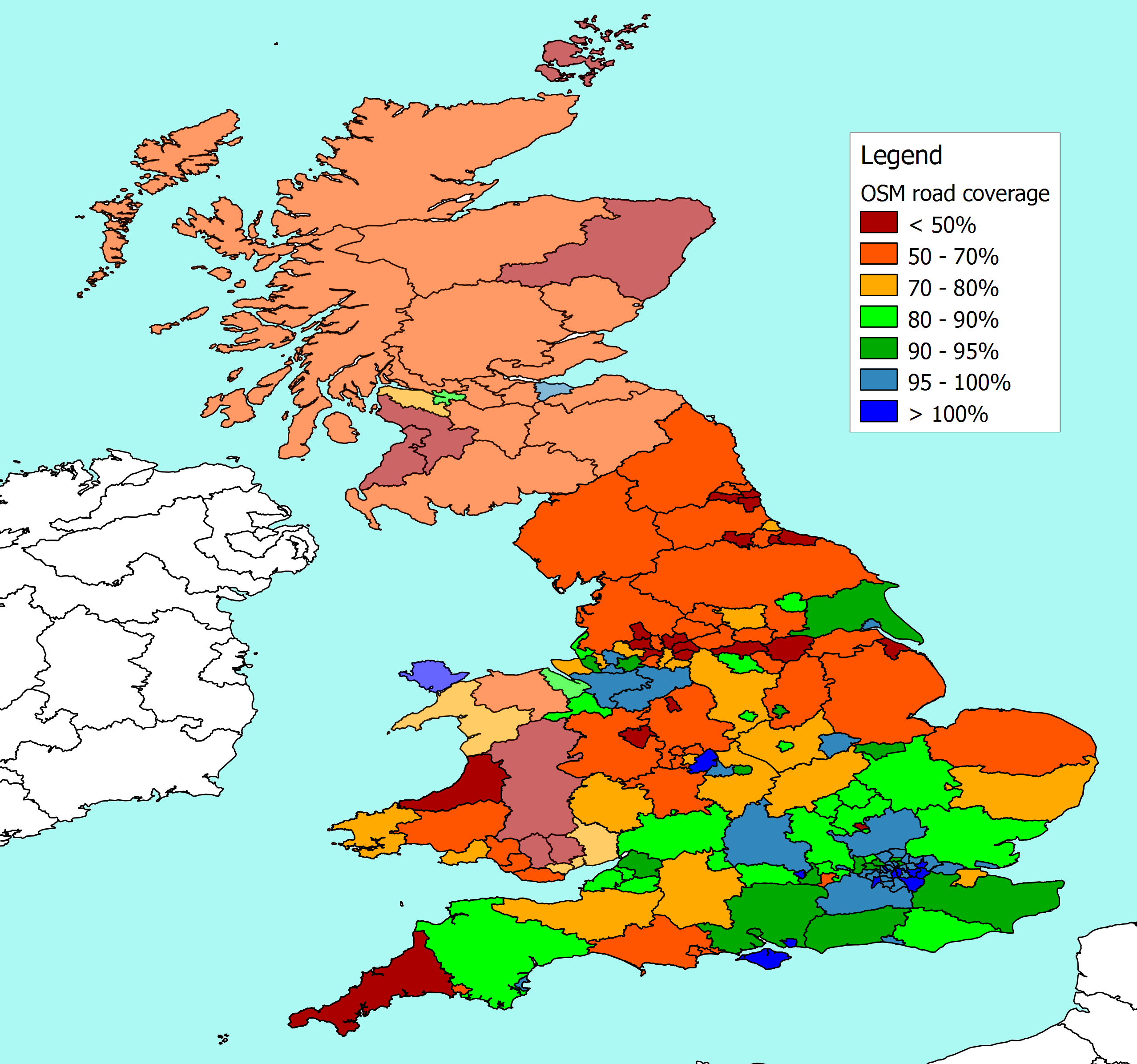
Nobody seems to like the colouring on this attempt very much, so that will need some more work. But meanwhile, the headlines are that Anglesey and Edinburgh look well covered. Glasgow, Renfrewshire, and Gwynedd look pretty good. While Powys, Aberdeenshire, Orkney and Shetland are looking a bit thin.

For anyone interested in doing a similar exercise elsewhere in Europe, I don't know what detailed figures are published at national level, but there are Eurostat figures for road lengths at the NUTS-2 level (i.e. the next largest geographical grouping after those I am using here). Eurostat only split "Motorways" and "Other Roads" so dealing with dual carriageways etc is going to be a bit iffy. However, I've done a quick comparison of their numbers for the UK, and the rough figures (motorways * 2 + other roads) gives me a total that isn't a million miles away from more detailed calculations. The Eurostat figures are here under "Regional Transport Statistics", and the Eurostat shapefiles that I used are here


There's another version, with brighter colours here

Monday, 17 August 2009

Navigation


One of the odd things about the ride I did yesterday was that it crosses four different Ordnance Survey Landranger maps. My "home" sheet (Reading & Windsor) would have got me as far as Slough, though I shouldn't need it for such a familiar route, and it didn't come out of the bag.

From there to the top of the Wey Navigation is on the West London sheet (176) and I checked that one a couple of times, but along the canal itself it only took me as far as the point where the M25 crosses.

Then I was on the Dorking and Reigate sheet (187) almost until I reached Newark lock (in the picture). After that I would have been following the route on the Aldershot & Guildford sheet (186) except that I didn't have a copy of that one.

Not that it particularly matters along a canal of course. Even at my most vague and woolly, it would be quite an achievement to get lost on a towpath. Except for one thing.... approaching Guildford there are a couple of different options, and I suspect I didn't pick the best route into the centre.

Getting home from the centre of Guildford was another matter. My planning for the day had been bit sloppy to put it mildly. Basically I knew that if I headed north I would end up somewhere familiar, and I hadn't given it much more though than that. I've got the OSM cyclemap on the GPS, and since that now has route finding I was pretty relaxed about getting home.

In the event, though, the distance from Guildford to home proved a bit too much for the GPS. I fiddled around with partial routes for a while without too much luck, and in the end I realised I didn't have time to drift much off a straight line, so I went and found a book shop, and bought a copy of the local OS sheet.

That got me as far as Bagshot. Not that it needed much checking since I was now following a main road, with plenty of signposts. From Bagshot I was back on the OS sheet that I had started from, but more importantly, I was on familiar ground, and the GPS route finder was coping, and ticking down the remaining distance. So from Bracknell I was able to call home and let them know (more or less) exactly how late I was going to be.

Unfortunately slippy maps on the internet don't function too well out on the road. The GPS is wonderful, but it isn't really up to finding 20 mile routes on the bike yet (though it is getting there). I am trying to make a convincing case to myself that an Internet tablet with GPS and Maemo Mapper would be just the thing (without much luck). So in reality I suspect that I'm going to be carrying bundles of landranger maps for a while yet.

It seems a bit ironic that all this came to the fore along a canal route call the "navigation".