A month ago the ITO OSM analysis was showing my local area as having reached 74% coverage. It ranked about half way up the list, with roughly equal numbers of other areas showing better and worse levels of coverage.
Checking out some of the inconsistencies has given me plenty of excuses for pleasant outings over the last month. Several bank holidays later we have just passed 90% coverage, and risen to rank three-quarters of the way up the table. About a quarter of local areas still have better coverage, and of course, several of them are also improving, so the bar is continually rising.
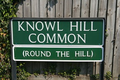
That still leaves a gap of 10% to close, and some of the remaining inconsistencies are a bit of a puzzle. This is one. With that sign, the OSM name tag on the road was previously set as "Knowl Hill Common (Round the Hill)". I'm not sure, but I think it might have been my contribution in the first place. It certainly seems a reasonable interpretation to me.
However, on OS Streetview this road is named "Knowl Hill Common". A cursory search of the internet suggests that local addresses also tend to prefer "Knowl Hill Common". On the ITO analysis, half of the road was highlighted as inconsistent, and the other half wasn't.
After mulling this over (note to self: must get a life), I decided to change the name tag on OSM to "Knowl Hill Common", with an alt_name tag of "Round the Hill".
Of course the beauty of all this is that anyone who feels strongly, or has better local knowledge. can always change it back, or change it to something different. The location is here.
At the same time, and again thanks to ITO, I've uncovered a couple more named roads that I'd previously missed, despite having ridden past them regularly for the last three years. I can't believe there are so many of these bits and pieces that I hadn't noticed before, but in my defence, both of these look a bit like private driveways from the road. Closer scrutiny on the ground shows that they do have real names, and both are now fixed.
And finally, to my relief, I've managed to fix a mess that I made of one of islands in the Thames. I screwed up one of the riverbank multi-polygons last night. I realised shortly after that this had drained a short section of the river upstream from Windsor. It wasn't a difficult mistake to fix, but it was a bit of an uncomfortable wait before the solution was rendered again. All seems to be well now.
Onward and upward.

No comments:
Post a Comment