Showing posts with label OSM. Show all posts

Thursday, 22 April 2010

Where do road names come from?


A lot of road names commemorate the great or good (Victoria Road, Kingsway). Many provide directions to the next big town (London Road, Bath Road). A few have ancient roots (apparently Watling Street derives from the Old English Wæcelinga Stræt; Fosse Way from from the Latin fossa, meaning ditch).

But out in the countryside, the vast majority of names seem to be functional.

My own theory is that before the gentleman from the Ordnance Survey arrived with his notebook the locals didn't really need to name the different paths through their village. Looking at the common names for a lane on OSM most are either based on an important building (Church Lane, Mill Lane, School Lane, Hall Lane, Rectory Lane,...), or they describe the lane itself (the list of examples like Green Lane, Long Lane, Sandy Lane, Marsh Lane, Water Lane, Broad Lane goes on, and on).

I imagine the surveyor turning up in the pub, putting down his top hat, and asking "what do you call that path, and what do you call that one?" and the ancestors of Eddie Grundy and his mates getting their heads together to think up some suitable names.

"Well that one's stony, and that one goes to the windmill, and the parson wouldn't be happy if we told him what we really call that one, so I suggest we tell him it's called Love Lane". "G'evening your lordship, I'm just telling old Amos here that we ought to name one of these paths after your lovely daughter Holly, who does so much for the poor folk of the parish. That would be very kind sir, I'll just have a pint please."

I've put a list here of the common names for a lane on OSM, ranked by the number of segments and total length.

Monday, 5 April 2010

More OSM coverage

The release of Ordnance Survey data has triggered a mass of activity, and there is no doubt a lot more to come.

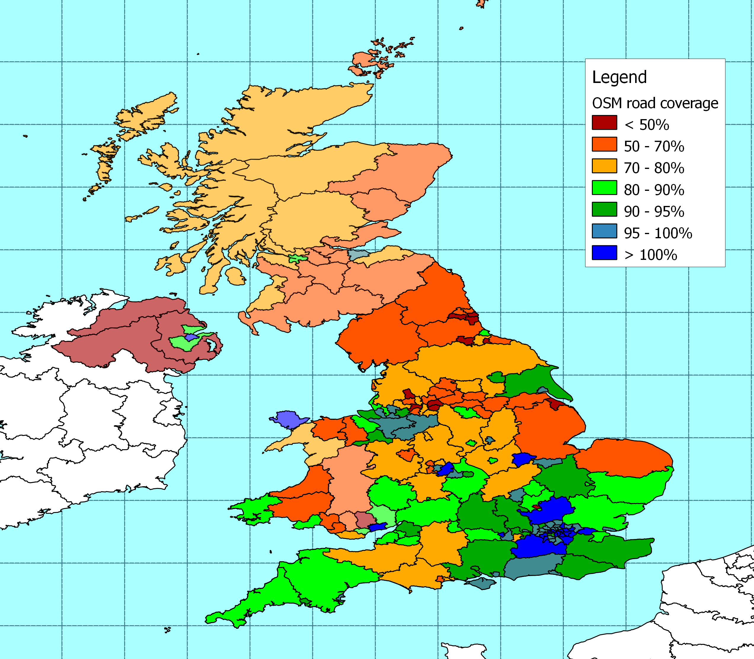
For my part I've started with another simple comparison between DfT statistics on the length of roads in Great Britain, and the length that has already been plotted on OSM - using the Ordnance Survey boundary data to break out the figures for each local authority.

I've been able to identify more than three quarters of the roads measured by DfT, and the map shows how these are distributed across different local authorities. Boundaries for Northern Ireland are not included in the OS data as far as I can see, so they do not appear here.

The best coverage is in the south-east of England (with Bracknell and Luton as thin spots). There is some strong coverage in other centres of activity. The biggest shortfalls (total road length to be added) are in Aberdeenshire, Cumbria, Lincolnshire, Norfolk, N. Yorkshire and Powys. The highest proportion of missing roads is in Baenau Gwent and N. E. Lincolnshire. The figures for Lincolnshire, N. E. Lincolnsihre and Northumberland all suffer from a particularly high proportion of roads with ambiguous tagging - which I have excluded from this version.

For anyone interested in how this breaks down in more detail, the data is here -

With ward boundaries now available from OSM, I'm hoping that I can now take some of the analysis to a more detailed level, but more importantly it will be good to see some of the gaps filling over the weeks to come.

Tuesday, 30 March 2010

OSM coverage

It’s been three months since I last tried to measure road lengths on OSM against the Department for Transport statistics, and I thought there might be some interest in how things are progressing.

Across the UK my measure of the length of roads in the OSM database has increased by around 2% in the last three months so the overall pattern of coverage stays much the same as it was in January. Major roads are well covered and I reckon that about 72% of minor roads are now on OSM.

The most significant increases in coverage of England have been in: Stoke-on-Trent (43% more roads), Luton (26%), Bolton (18%), and Redcar & Cleveland (16%). Another eleven local authority areas have seen the length of roads on OSM increase by more than 10% (Vale of Glamorgan, Walsall, Poole, Northumberland, Stockton-on-Tees, Bournemouth, Staffordshire, Dudley, North East Lincolnshire, Medway and Dorset).

There has also been big improvement in coverage of the highlands and islands. There's almost 10% more coverage across much of the north and west of Scotland, taking the proportion of roads that appear in the OSM database to more than 70%.

It’s the first time I’ve tried to add N. Ireland. I used NUTS3 boundaries (as I did in Scotland and parts of Wales) because I can't find usable Local Government boundaries. The figures show that coverage is concentrated around Belfast, which is not a big surprise.

The raw data is here.

Wednesday, 24 February 2010

Places to map


As the weather improves we are all going to be out and about tracing roads for OSM. Larger towns and bigger areas that need attention are fairly well known, but as the amount of content on the map improves it can be difficult to find smaller and more local places where a short session could make a difference quickly.

So I've been messing around with OSM data again, trying to figure out a way to highlight areas that look as though they need some attention. The result is here.

This is very much a first cut, and it doesn't always get things right, but I think it gets them right often enough to be useful.

It starts with a list of about 1,600 UK settlements, and then uses a variety of techniques based on road density, type of road, and population to try and guess which settlements seem to have a lot of roads on the map for their size, and which don't have many. The green areas look as though they are well covered, and the red areas look as though they could do with some attention. The grey areas fall somewhere between the two.

There is more detail on how it works, and the subsequent discussion on the Talk-GB mailing list

It needs more work to improve the process, and a number of good suggestions are coming in on how to do that. I'd welcome more comments and ideas. But more important than perfecting the measurement is to get more roads on the map. So what I really hope is that this will help members of the community to find some handy places where they can quickly make a difference by plugging a few gaps.

Please remember though that this is a little bit hit-and-miss. It's probably a good idea to check some other sources as well before rushing out to your nearest red blob with the GPS.

Saturday, 20 February 2010

Bracknell

Around here the most noticeable gaps in the OSM map are in Bracknell, and today I decided I should go and try to fill some of them. My GPX trail, and the results are shown in the map above.

There has been some discussion on the Talk-GB lists about whether the locations suggested for this summer's mapping parties are going to be attractive enough, but there are also comments that in practice it doesn't make much difference. It wouldn't be difficult to be a bit sniffy about Bracknell as a mapping destination, but to my mind that misses the point. This isn't tourism. From home it's a pleasant ten mile ride out to Bracknell through the Walthams and Shurlock Row. When I got there, the residential areas that were missing weren't anything remarkable, but they seem pleasant enough. For me though, the real pleasure is in the ride. Mapping a bit of Bracknell is as good an excuse as any to get on the bike - with the added bonus that I'm not just trundling around - there is some purpose to the exercise.

As a relatively new town Bracknell is quite good at separating cycles and cars. There's a grid of fast roads, but then the residential roads are arranged so that they can't be used as rat-runs. On top of the road network  there is a network of footpaths and cycle paths so that people walking or cycling have access to plenty of short-cuts that cars cannot use. I imagine that it all works nicely for a local who knows their way around. But when you don't know the town it's a bit difficult to navigate on a bike. In practice the cycle routes seem quite fragmented and complicated, and the through roads are fast and busy. It seems to me that this should be an ideal environment for route finding with a GPS. A GPS should be able to get me from one side of Bracknell to the other, without needing any local knowledge. But there are currently lots of gaps in the map.

Today I was on the bike, but my intent was to plot roads. I didn't want to confuse the trace of the roads with paths that are restricted. So I didn't trace all the connections that were open to bikes. As a result, anyone who uses my contribution to route-find on a bike could be taken around some unnecessarily convoluted journeys. There are probably ways that I could have done this better, and I should give it some thought. In the meantime, there are a few more miles of residential road in north-west Bracknell that weren't on the map a few hours ago - but I'm conscious that I've only contributed part of the data that needs to be added.

When I did the editing, I was reminded that although I've added the odd detail to OSM from my trips over the lest few weeks, and I've edited some content from NPE, I haven't added any significant traces since before Christmas. It's a bit of a call to action, and there are still some gaps to fill in Bracknell.

Thursday, 18 February 2010

Road densities on OSM

This is one of those things that you do, then you are not quite sure whether it was worth it or not.

I calculated the road density for each of the "Pay scale areas" that arrived with the OSM Naptan import. I thought that these would be fairly thickly populated areas, so a low road density would highlight places where there were roads missing from the map, and hence help to prioritise more attention.

Road density is calculated as the length of roads in km, divided by the area in sq. km. I've included motorways (and links), primary, secondary, tertiary, unclassiifed and residential roads. I've not included cycleways, paths and bridleways, etc.  The data extract I used is actually a few weeks old, but that shouldn't make a lot of difference (unless someone has added a mass of new roads in a particular area).

The highest quartile of areas (by road density) are shown in blue, then the following quartiles in green, orange and red. In other words red areas don't have many roads for the area, blue areas do.

Looking at the result, things obviously are not as simple as I expected. Anyway, for what it's worth, this is what it looks like. Maybe someone else will spot a way of making use of the information.

Monday, 4 January 2010

OSM cycle map for Garmin


The most common search terms that bring people here are the various permutations of "open", "cycle", "map", and "garmin". So it's only right to pay tribute to all the people who have contributed to the thing that so interests these searchers.

I downloaded the latest version a few days ago, and tried it out yesterday on the way to Ivinghoe and back. There are a few minor glitches, but basically it works fine.

Richard Fairhurst produced the version of the img file I used, and it can be reached here - http://richard.dev.openstreetmap.org/garmin/gmapsupp.img. There are more details here - http://wiki.openstreetmap.org/wiki/OSM_Map_On_Garmin/Cycle_map. There are various alternatives here - http://wiki.openstreetmap.org/wiki/OSM_Map_On_Garmin/Download

This is great work by all involved, and after seeing how grumpy the OSM mailing lists are getting, I hope they all realise that it is very much appreciated.

Sunday, 15 November 2009

John Hampden

This is John Hampden, who was a 17th century politician. He played a leading role in early parliaments, and he was killed during the civil war. I can't help feeling that I should know more about him, but I don't. These people do though.

The reason he is here is that today I set off to map the Hampden cycle route in Buckinghamshire for the OSM cycle map. It is one of three loops that make up the Chiltern Heritage Cycling Trail. The Hampden route runs for 25 miles or so, to the northwest of Amersham. It is named after John - he didn't mark it out, because he didn't have a bicycle. But he lived in the area and represented a nearby constituency.


Hampden routeThis was the local council's Millennium project, so there has been plenty time for moss to grow on the signs. Helpfully that shows which way we are heading because moss always grows on the north side. Or is it the south?

Either way it is a nice route, through some pretty villages, with some good views. I covered most of it today, and I look forward to going back soon to do the rest.


Thursday, 29 October 2009

Milton route, the clod's cut


Cycle map has now rendered my efforts last weekend to trace the Milton Cycle Route in Buckinghamshire. As a result I can now see where I made a couple of errors (paradise lost). I've fixed them in the database today, but it will be another week before it is rendered again, and I won't see whether the fixes worked (paradise regained) until next thursday. Meanwhile the glitches are almost cunningly hidden by a page curl in the image above. They will be visible to all on the tile server for the next week.

My little contributions are a tiny pimple on the mass of information that has been produced collectively for OSM. It's a slight disappointment when I don't get it quite right, but it still pleases me to see my efforts appear. Nowadays, Mapnik renders database changes almost immediately, but that doesn't help a lot when adding cycle routes to existing ways. The cycle map only seems to render on Thursdays. The wait is a bit frustrating, and it's a little embarrassing to know that my mistakes will be around for a few more days, but there are also some advantages to this delay in the process. The sense of anticipation lasts for longer. More importantly, by the time I see the results from one weekend, another weekend is looming. The results of one edit are a bit of an encouragement to get out on the bike and fix the next gap on my to-do list. Let's hope for decent weather this coming weekend.

Sunday, 25 October 2009

Milton route, director's cut


I plotted bits of the Milton cycle route last weekend, and today I think I've managed to trace the rest. We'll see what it looks like when the OSM cycle map is rendered later in the week. At the moment it's a bit of a mess because I made a mistake in tagging last week.

Apart from getting caught in one shower, and a bit of a gusty wind today wasn't at all bad for a ride; and because of the clocks going back I managed to make quite an early start, and for once I was home in plenty of time for dinner.

The route meanders around Penn, Amersham, Chorleywood, and the Chalfonts. I rode through Beaconsfield on the way there and back. Some of the best parts were riding through autumn woodland, particularly here in Philipshill Wood. At one point I got mixed up with a bunch of runners, who were involved in a big event. Lots of people had come out to cheer then on, and for several miles it felt as though I had a crowd of supporters.

I enjoyed the day, but I have mixed feelings about the route itself. It covers an interesting variety of landscape and some pleasant towns and villages. But there are too many suburbs for my liking. It's probably inevitable in the Chilterns that the route is quite hilly, but it is also a bit complicated. There were too many junctions where I needed to check the map, and so many changes of direction that it was difficult to keep track of where I was heading. There are several off-road stretches that don't really work with a road bike, and although they could be bypassed, that would mean missing some of the best parts of the ride.

The route borders on a number of fairly large towns, and I suspect it would suit someone who lived locally, who wanted to get to know the area better. Coming from further afield, there are more interesting alternatives.

Sunday, 18 October 2009

Milton route revisited

After yesterday's fiasco, today I decided to have a another go at tracing the southern part of the Milton route. This is a 25 mile local cycle route in Buckinghamshire that loops southwards from Amersham, through Chalfont Saint Peter, Chalfont Saint Giles, Seer Green, and Penn. It is named after John Milton, who retired to Chalfont Saint Giles to avoid the plague in London.

Yesterday I traced a little bit of the route around Seer Green, but I got horribly lost. Yesterday evening I took another look at the maps, worked out where I had gone wrong, and today I managed to trace the section from Seer Green almost to Penn. In the grand scheme of things none of that is very impressive, but I enjoyed myself, so that's OK.

It was a lovely day for a ride. A little bit nippy, but it was nice sunny autumn weather, and this part of south Buckinghamshire is pleasant. Not all of the route is great, but the woodland where I lost my way yesterday was particularly nice, and I rode through some pleasant villages.

Paradise would be putting it a bit strong, but I didn't get lost. So "Pleasant countryside navigated successfully" would be a bit more accurate than "Paradise Lost". If only John Milton had worked harder on his cadence and navigation skills, and wasted less time on blank verse he might have made a name for himself.

Tuesday, 8 September 2009

NHT on routes

Fans of the OSM cycle map might be interested to see how different local authorities are rated in the NHT survey for the information they provide on cycle routes. Darlington comes out well in the survey, and Liverpool does not come out well at all.

Of course, since this is measuring perceptions, rather than reality, it doesn't necessarily correspond to the quality of the information each authority provides.

I dont want to have a Boris experience, so lets say that people in Liverpool hold their council to higher standards than people in Darlington. Or perhaps people in Darlington don't like to grumble to market researchers. Or it could be that Darlington actually does provide better information on cycle routes. There are some oddities. I thought that TfL did all the cycle maps for London (and I think they do a pretty good job of it). But information on cycle routes is rated highly by people in Islington , and poorly by people in in Kensington.

Of the councils that are rated highly in this survey the residents of Milton Keynes and Bristol seem particularly well served. They have pretty good coverage on OSM, and they like their council maps. The council is seen as doing a good job in Darlington and Poole, but neither is particularly well covered by OSM.

OSM provides a good alternative for some of the councils that are not seen as providing good cycle route information themselves. This is particularly true of Liverpool, Torbay and Kensington. Other councils that are seem as weak, such as Northamptonshire, Wallsall, Stockport and Staffordshire are also a bit thin on OSM. Cyclists in Cornwall in particular could do with some help.

If there's a pattern to all this, then it's not one I can see.

The survey data is here, and there is an expanded version of my chart here.

Tuesday, 23 June 2009

Putting Stoke Poges on the map

I got another report out the door today, which is always worth a small celebration. So I decided to go for a decent ride after dinner.

This week Jack Thurston's Bike Show was covering the first part of his ride from London to Bristol. The programme is always worth a listen, and this one is particularly interesting to me because he was covering my local area, including Stoke Poges, Henley and the Chilterns.

But when I looked at the OSM map, most of Stoke Poges was missing. Fixing that seemed like another good excuse for a ride. So this evening I ended up covering 28 miles out to Stoke Poges, tracing most of the missing streets, then back home again.

It was a lovely evening for a ride. I've taken this week's total distance over 100 miles (and it's still only tuesday). I'm now 127 miles ahead of plan for the year, and to reach my annual goal I only need to average 57 miles a week for the next six months. Non-trivial, but I'm more on top of the plan than I've been all year.

So it's been a good day, although I forgot to take my little digital recorder with me to collect the street names, so it looks as though a return trip will be needed. Perhaps next time I'll finally get to see the famous bicycle window in St Giles' church.

Monday, 4 May 2009

Berkshire

It has taken me a while, but I have finally managed to get a decent outline of my local authority, and most of its neighbours, onto Open Street Map.

The picture shows how OSM Inspector judges my success. As far as I can see, the red lines are where different levels of boundary coincide, and I can't see a consistent way of tagging them to remove the error. Otherwise, the different authorities in what used to be Berkshire all seem to join up correctly, in closed loops.

Compared to adding roads and streams I found it remarkably difficult to get a satisfactory outline of the local authority. This is partly because boundaries are not clearly plotted on the out-of-copyright maps, and there have been some changes over the last fifty years or so. It's also partly because local authority boundaries coincide with a lot of other features, such as rivers. In some cases, a rough outline had already been added, and these had to be identified, and disentangled from neighbours so that I didn't do any damage. 

So a hat-tip of respect to those who are adding the other boundaries.

Tuesday, 31 March 2009

Cyclestreets

CycleStreets looks rather neat (British understatement). It's a beta status route planning site for UK cyclists, based on Open Street Map. I've tried it out on a few local routes, and it's not perfect, but it is pretty darn good.

No doubt it will get even better as time goes on and the data improves. Already it's the nearest that I've seen to a reliable service, and it is much easier to use than some others.

There is a feedback form for anything that looks squiffy. So why not give it a try? 

I'd suggest double checking anything it suggests by more traditional methods, because automatic route planning for cyclists is supposed to be pretty difficult. But it might suggest a few new ideas, and there should be plenty of scope for tinkering.

Monday, 2 March 2009

Sunderland

For some time, Sunderland has been one of the gaps on the UK Open Street map. It's the city where I was born, and dragged up. But it's a long way from where I live now. So it was a disappointment to me, but not one that I could do much about.

Now things seem to be filling up rapidly. It's good to watch the progress. It reminds me of places that were familiar in my childhood.

So many thanks to those involved.

Thursday, 28 August 2008

Round Berkshire Cycle Route


The changes I made to the mapping of the Round Berkshire Cycle Route have now been rendered, and pretty much the whole circuit can be seen on Open Street Map.
There are a couple of mistakes, where I tagged the route wrongly, and although I have now fixed them, it will be another week before the fixes appear on a new version of the map.
Also, I'm not really happy with the way that, after rendering, the local Round Berkshire route hides Sustrans regional route 52. This is no fault of the people who put all this together, who are doing a wonderful job. But I think the Sustrans route should receive precedence, so today I have slightly changed the way that I have tagged the Round Berkshire Route. The whole route is still in the underlying database, but (assuming I understand the rendering process) when the map is updated next week, where the Round Berkshire route follows a Sustrans route, the Sustrans route will be plotted, rather than the Round Berkshire Route.
Inevitably it's a bit of a compromise, but we'll see how it looks next week. There are a few alternative paths that I want to add next, and I haven't checked yet to see how much of this can be transferred to my GPS.
Meanwhile, I know that at least one visitor to Tlatet is riding parts of this route, so comments are welcome.


(The "official" map is here).

Thursday, 3 July 2008

Round Berkshire


Here is the current state of the round Berkshire route on Open Street Map, now that the additions I made at the weekend have been rendered.

The section around Maidenhead is marked on the map, as it is on the ground, as Sustrans regional route 52, which appears as light blue on the OSM cycle map. The section between Maidenhead and Reading pretty much corresponds to National Cycle Route 4 which is in red as a national cycle route. I have marked the rest as a local route, which appears as dark blue.
I haven't checked every piece of the Maidenhead / Reading stretch yet, although I have marked a slight difference between how the two routes negotiate the centre of Wargrave, and I know there is some work to do where the Round Berkshire Route appears to dive off into Woodley.
The section from Wargrave to Windsor seems fairly complete. I'm pretty confident that I've captured the main outline of the section betwen Newbury and Windsor, though there may be some tweaking to do at a detailed level. The section from Reading to Hungerford and back to Newbury is still to be done. And there are quite large sections away from the Reading / Maidenhead / Windsor area where the route appears to pass through unmapped territory.

The official route map and guide is here.

Friday, 9 May 2008

Weekly roundup


With the aid of a bank holidy weekend, there have been several notable milestones this week:
  • The first time my total weekly mileage has gone into three figures (106miles)
  • I finshed marking up regional route 52 round Maidenhead, and have seen it rendered on the OSM cycle map
  • I have cycled to a business meeting for the first time (albeit an informal one, over lunch at a nearby pub)
  • I received a comment on the blog from Fat Lad
  • I completed my Winter Hill loop at an average of 13mph
Things seem to be getting back on track after my unimpressive efforts in April.