It’s been three months since I last tried to measure road lengths on OSM against the Department for Transport statistics, and I thought there might be some interest in how things are progressing.
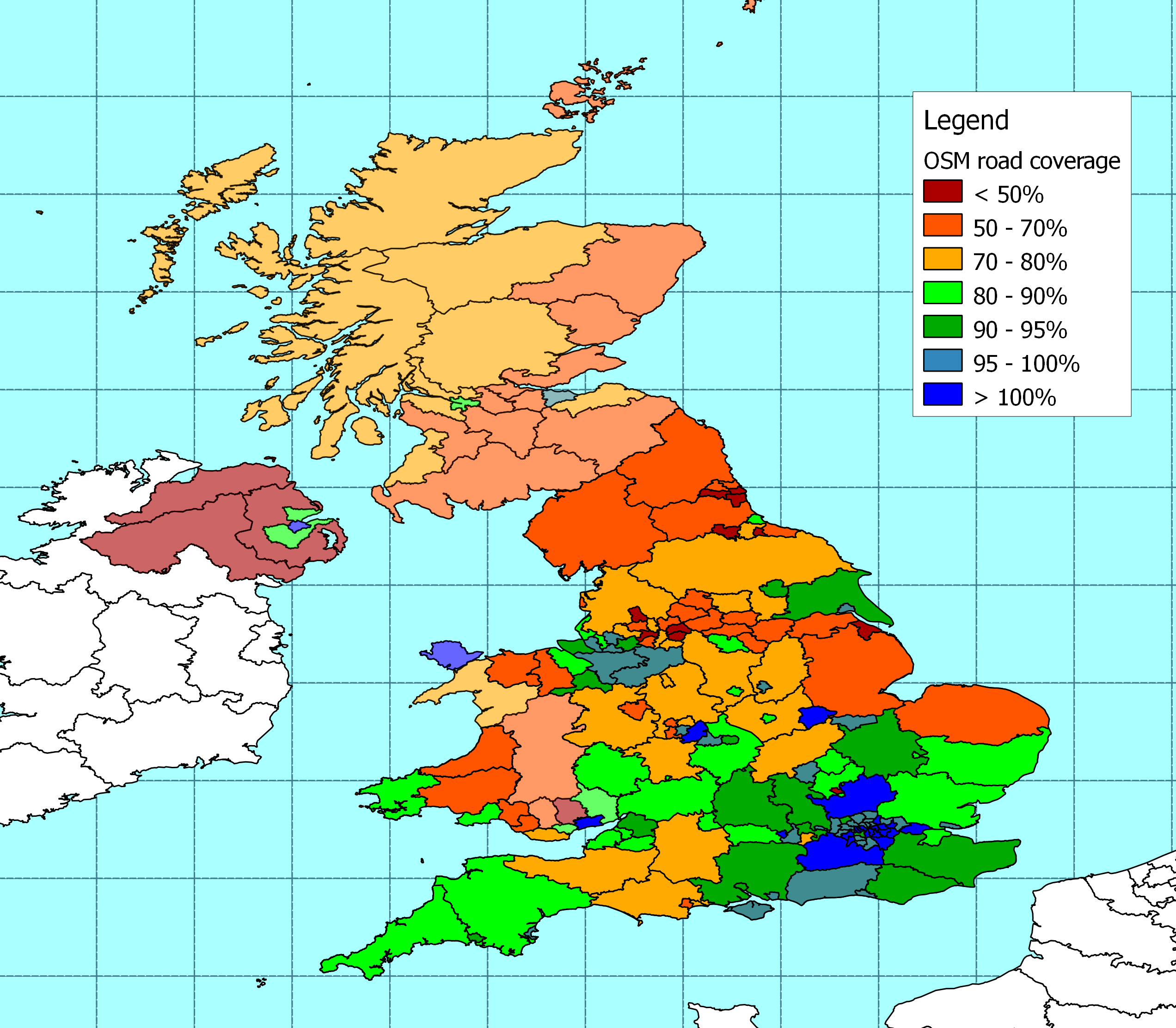
Across the UK my measure of the length of roads in the OSM database has increased by around 2% in the last three months so the overall pattern of coverage stays much the same as it was in January. Major roads are well covered and I reckon that about 72% of minor roads are now on OSM.
The most significant increases in coverage of England have been in: Stoke-on-Trent (43% more roads), Luton (26%), Bolton (18%), and Redcar & Cleveland (16%). Another eleven local authority areas have seen the length of roads on OSM increase by more than 10% (Vale of Glamorgan, Walsall, Poole, Northumberland, Stockton-on-Tees, Bournemouth, Staffordshire, Dudley, North East Lincolnshire, Medway and Dorset).
There has also been big improvement in coverage of the highlands and islands. There's almost 10% more coverage across much of the north and west of Scotland, taking the proportion of roads that appear in the OSM database to more than 70%.
It’s the first time I’ve tried to add N. Ireland. I used NUTS3 boundaries (as I did in Scotland and parts of Wales) because I can't find usable Local Government boundaries. The figures show that coverage is concentrated around Belfast, which is not a big surprise.
The raw data is here.
3 comments:
I thought you might like to know that as part of our effort to complete Cambridgeshire this summer, I recently evaluated progress in terms of population. Because of the pretty systematic approach here, I can be rather confident I know what is complete and what is not. I came up with an estimate of 93%, which is spot on for your estimate by road length, and validates your approach at least here. (The two largest missing settlements are Whittlesey and Ramsey with a combined population of around 24,000).
Thanks David. That's good news.
How are you doing the analysis in Cambridgeshire? As you may have seen I've been trying to automate measurement of road densities in settlements across the UK, with mixed success. The latest version is here - http://www.reedhome.org.uk/Documents/osmembed.html?kml=KML/osmcategorynew.kml . I'd be interested in comparing notes.
PS - I notice my settlement map managed to pick up Whittlesey. Where my process thinks there are other thininsh places in Cambs it looks as though its because I've not got the settlement boundary centred properly.
Post a Comment